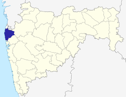
Palghar district
|
Palghar District पालघर जिल्हा |
|
|---|---|
| District Of Maharashtra | |
 Location in Maharashtra |
|
| Coordinates: 19°41′49″N 72°46′16″E / 19.697029°N 72.771249°ECoordinates: 19°41′49″N 72°46′16″E / 19.697029°N 72.771249°E | |
| Country |
|
| State | Maharashtra |
| Divisions of Maharashtra | Konkan division |
| Headquarters | Palghar |
| Government | |
| • Body | District Council |
| Area | |
| • Total | 5,344 km2 (2,063 sq mi) |
| Population (2011 Census) | |
| • Total | 2,990,116 |
| • Density | 560/km2 (1,400/sq mi) |
| Languages | |
| • Official | Marathi |
| Time zone | IST (UTC+5:30) |
| ISO 3166 code | IN-MH |
| Vehicle registration | MH-04 (Thane RTO), MH-48 (Palghar District RTO) |
| Palghar | ||||||||||||||||||||||||||||||||||||||||||||||||||||||||||||
|---|---|---|---|---|---|---|---|---|---|---|---|---|---|---|---|---|---|---|---|---|---|---|---|---|---|---|---|---|---|---|---|---|---|---|---|---|---|---|---|---|---|---|---|---|---|---|---|---|---|---|---|---|---|---|---|---|---|---|---|---|
| Climate chart () | ||||||||||||||||||||||||||||||||||||||||||||||||||||||||||||
|
||||||||||||||||||||||||||||||||||||||||||||||||||||||||||||
|
||||||||||||||||||||||||||||||||||||||||||||||||||||||||||||
| J | F | M | A | M | J | J | A | S | O | N | D |
|
0.6
31
12
|
1.5
31
15
|
0.1
33
21
|
0.6
33
24
|
13
33
26
|
574
32
26
|
868
30
25
|
553
29
25
|
306
30
24
|
63
33
23
|
15
33
19
|
5.6
32
10
|
| Average max. and min. temperatures in °C | |||||||||||
| Precipitation totals in mm | |||||||||||
| Source: Indian Meteorological Department | |||||||||||
| Imperial conversion | |||||||||||
|---|---|---|---|---|---|---|---|---|---|---|---|
| J | F | M | A | M | J | J | A | S | O | N | D |
|
0
87
54
|
0.1
88
59
|
0
91
69
|
0
92
75
|
0.5
92
78
|
23
89
78
|
34
86
77
|
22
85
76
|
12
86
75
|
2.5
91
74
|
0.6
92
65
|
0.2
90
50
|
| Average max. and min. temperatures in °F | |||||||||||
| Wikipedia
...
| |||||||||||
