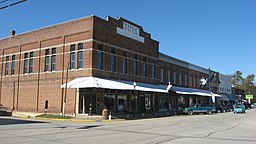
Palestine, Illinois
| Palestine | |
| Town | |
|
Palestine's commercial district
|
|
| Country | United States |
|---|---|
| State | Illinois |
| County | Crawford |
| Coordinates | 39°0′8″N 87°36′44″W / 39.00222°N 87.61222°WCoordinates: 39°0′8″N 87°36′44″W / 39.00222°N 87.61222°W |
| Area | 0.79 sq mi (2 km2) |
| - land | 0.79 sq mi (2 km2) |
| - water | 0.00 sq mi (0 km2) |
| Population | 1,369 (2010) |
| Density | 1,832.3/sq mi (707/km2) |
| Chartered | 1811 |
| Incorporation as a town | February 15, 1855 |
| Timezone | CST (UTC-6) |
| - summer (DST) | CDT (UTC-5) |
| Postal code | 62451 |
| Area code | 618 |
Palestine is an incorporated town in Crawford County, Illinois, United States. The population was 1,369 at the 2010 census, a 0.2 percent increase from 1,366 in 2000.
Palestine is located at 39°0′8″N 87°36′44″W / 39.00222°N 87.61222°W (39.002214, -87.612110).
According to the 2010 census, Palestine has a total area of 0.79 square miles (2.05 km2), all land.
It is said that French explorer Jean Lamotte first gazed upon this region in 1678. He gave it the name Palestine, as it reminded him of Palestine, the Biblical land of milk and honey.
Palestine was chartered in 1811, while the area still belonged to Virginia, and is one of the oldest towns in the State of Illinois. It was named the seat of Crawford County in 1818. Elections in 1843 moved the county seat to a new site, which would become the town of Robinson. It was officially incorporated as an Illinois town in 1855.
Palestine, Texas was named after the city by Daniel Parker.
As of the census of 2000, there were 1,366 people, 625 households, and 400 families residing in the town. The population density was 1,832.3 people per square mile (703.2/km²). There were 714 housing units at an average density of 957.7 per square mile (367.6/km²). The racial makeup of the town was 99.12% White, 0.07% African American, 0.22% Asian, 0.07% Pacific Islander, and 0.51% from two or more races. Hispanic or Latino of any race were 0.66% of the population.
...
Wikipedia


