Palatine, New York
| Palatine, New York | |
|---|---|
| Town | |

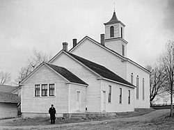
Trinity Lutheran Church in Stone Arabia (1936)
|
|
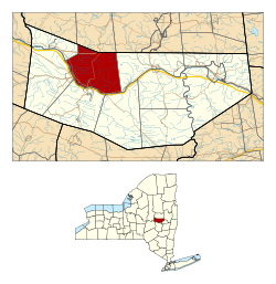
 Location in Montgomery County and the state of New York. |
|
| Coordinates: 42°57′0″N 74°33′46″W / 42.95000°N 74.56278°WCoordinates: 42°57′0″N 74°33′46″W / 42.95000°N 74.56278°W | |
| Country | United States |
| State | New York |
| County | Montgomery |
| Government | |
| • Type | Town Council |
| • Town Supervisor | Sara Nicoli (D) |
| • Town Council |
Members' List
|
| Area | |
| • Total | 41.7 sq mi (108.1 km2) |
| • Land | 41.2 sq mi (106.7 km2) |
| • Water | 0.5 sq mi (1.3 km2) |
| Elevation | 778 ft (237 m) |
| Population (2010) | |
| • Total | 3,240 |
| • Density | 78.9/sq mi (30.5/km2) |
| Time zone | Eastern (EST) (UTC-5) |
| • Summer (DST) | EDT (UTC-4) |
| FIPS code | 36-56099 |
| GNIS feature ID | 0979337 |
Palatine is a town in Montgomery County, New York, United States. The population was 3,240 at the 2010 census. The named is derived from the Palatinate in the Rhineland, the homeland of the Germans who were the earliest European settlers of this region.
The Town of Palatine is located on the north side of the Mohawk River in the northwestern part of the county.
Settlers in this area in the mid-18th century were primarily ethnic Germans from the Palatinate. Suffering from French raids in their territory, they had become refugees. Queen Anne of England arranged for the transport of several thousand Protestant Germans to the colony in 1710 and later; they first worked in camps run by the English along the Hudson River to pay off the cost of passage.
The Germans built the Palatine Church in 1770, which still holds Lutheran services. It was listed on the National Register of Historic Places in 1973.
The Town was formed in 1788 after the American Revolutionary War from the "Palatine District" in the newly organized Montgomery County. In 1797, part of the town was used to form the Town of Salisbury (now in Herkimer County). The formation of other towns that eventually were in adjacent counties further reduced Palatine. The Town of St. Johnsville was also created in Montgomery County.
According to the United States Census Bureau, the town has a total area of 41.7 square miles (108 km2), of which, 41.2 square miles (107 km2) of it is land and 0.5 square miles (1.3 km2) of it (1.25%) is water.
...
Wikipedia
