Padali
|
Padali पाडळी (हेळ) |
|
|---|---|
| Village | |

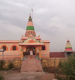
Heljai Mandir Padali
|
|
| Location in Maharashtra, India | |
| Coordinates: 17°28′48″N 74°11′09″E / 17.4801163°N 74.1856956°ECoordinates: 17°28′48″N 74°11′09″E / 17.4801163°N 74.1856956°E | |
| Country |
|
| State | Maharashtra |
| District | Satara |
| Government | |
| • Body | Grampanchayat |
| • Sarpanch | Manjusha Bhoj |
| Elevation | 56 m (184 ft) |
| Population (2011) | |
| • Total | 3,550 |
| Demonym(s) | Padalkar |
| Time zone | IST (UTC+5:30) |
| PIN | 415106 |
| Telephone code | +91-2164 |
| Vehicle registration | MH- 50 |
| Website | www |
Padali ( पाडळी) is a census village in the Satara district, in the Indian state of Maharashtra. It is surrounded by a Big Mountain. There is a big temple of Heljaimata Madir at Village. Agriculture is the main land use in the village with more than 75% of the total area being used for agricultural activities.
Padali is a large village located in Karad of Satara district, Maharashtra with total 350 families residing. As of 2011[update] India census, has population of 3560 of which 1689 are males while 1871 are females as per Population Census 2011.
In Padali village population of children with age 0-6 is 308 which makes up 10.75% of total population of village. Average Sex Ratio of Padali village is 1063 which is higher than Maharashtra state average of 929. Child Sex Ratio for the Padali as per census is 833, lower than Maharashtra average of 894.
Padali village has higher literacy rate compared to Maharashtra. In 2011, literacy rate of Padali village was 86.51% compared to 82.34% of Maharashtra. In Padali Male literacy stands at 92.14% while female literacy rate was 81.36%.
As per constitution of India and Panchyati Raaj Act, Padali village is administrated by Sarpanch (Head of Village) who is elected representative of village.
Schedule Caste (SC) constitutes 9.77% while Schedule Tribe (ST) were 0.77% of total population in Padali village.
Marathi is the local language. The village normally shows unity as people from all castes Mainly Hindu Maratha and other which include Brahman, Lohar, Shimpi, Nhavi, Sonar, Parit, Mali, Chambar,Dhangar, Mang, Mahar, Boudhh etc.live in it. Two clans prominent in Padali are Jadhav and Shinde clans.Other surname clans also there like Chavan, Pawar, Kadam, Wagmode, etc.
As per constitution of India and Panchyati Raaj Act, Padali village is administrated by Sarpanch (Head of Village) who is elected representative of village.
List of Sarpanch
Padali is a village in Karad Taluka in Satara District of Maharashtra State, India. It belongs to Desh or Paschim Maharashtra region and to Pune Division. It is located 32 km towards South from district headquarters Satara, 28 km from Karad, 276 km from state capital Mumbai. Pin code is 415106 and post office is Padali (Satara). Gaikwadwadi(1.5 km), Gosavewadi(1.5 km), Banugadewadi(1.3 km), Wather( 5.3 km ), Sathewadi( 2.5 km ), are the nearby villages to Padali. Padali is surrounded by Karad Taluka towards North Kadegaon Taluka, Kadegaon Taluka towards South, Koregaon Taluka towards east, Patan Taluka towards west.
...
Wikipedia

