Pünderich
| Pünderich | ||
|---|---|---|
|
||
| Coordinates: 50°2′29″N 7°7′56″E / 50.04139°N 7.13222°ECoordinates: 50°2′29″N 7°7′56″E / 50.04139°N 7.13222°E | ||
| Country | Germany | |
| State | Rhineland-Palatinate | |
| District | Cochem-Zell | |
| Municipal assoc. | Zell (Mosel) | |
| Government | ||
| • Mayor | Werner Lay | |
| Area | ||
| • Total | 5.41 km2 (2.09 sq mi) | |
| Population (2015-12-31) | ||
| • Total | 847 | |
| • Density | 160/km2 (410/sq mi) | |
| Time zone | CET/CEST (UTC+1/+2) | |
| Postal codes | 56862 | |
| Dialling codes | 06542 | |
| Vehicle registration | COC | |
| Website | www.puenderich.de | |
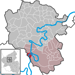
Pünderich is an Ortsgemeinde – a municipality belonging to a Verbandsgemeinde, a kind of collective municipality – in the Cochem-Zell district in Rhineland-Palatinate, Germany. It belongs to the Verbandsgemeinde of Zell, whose seat is in the municipality of Zell an der Mosel.
The municipality lies on the river Moselle inside a bend, on the right bank, not far upstream from Zell, which lies roughly 3 kilometres (2 mi) away as the crow flies.
The placename Pünderich is of Celtic origin. The oldest known name for the place is Pontaricum, meaning “Place with Ferry” or “Ferryman’s Place”.
Things such as ceramics and coins have been found in districts of Pünderich, suggesting a Roman settlement from the 1st century BC until the 3rd to 4th century AD.
About 250, the Franks showed up in the region for the first time. Only 25 years later, they went along with the Alamanni plundering the Moselle valley, leaving extensive destruction in their wake. Between 408 and 460 also came troubled times as Vandals, Suebi and Franks once more marauded across the land. Trade and transport collapsed utterly.
In the 6th century, the Frankish kings Christianized the Moselle valley and the first church in the Zeller Hamm – the local bow in the Moselle – arose. In 882, however, the Norman invasions led to a cultural collapse in the region.
...
Wikipedia


