Pácora, Caldas
| Pácora | |||
|---|---|---|---|
| Municipality and town | |||
|
|||
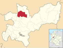
 Location of the municipality and town of Pácora in the Caldas Department of Colombia |
|||
| Location in Colombia | |||
| Coordinates: 05°31′33″N 75°27′32″W / 5.52583°N 75.45889°WCoordinates: 05°31′33″N 75°27′32″W / 5.52583°N 75.45889°W | |||
| Country |
|
||
| Department |
|
||
| Founded | 1831 | ||
| Area | |||
| • Total | 265.9 km2 (102.7 sq mi) | ||
| Elevation | 1,819 m (5,968 ft) | ||
| Population | |||
| • Total | 21,864 | ||
| Time zone | Colombia Standard Time (UTC-5) | ||
| Website | Official website | ||
Pácora is a town and municipality in the Colombian Department of Caldas. It is located in northern Caldas-Department, on the slopes of the Andes Central Mountains of the Republic of Colombia. With an average annual temperature of 18 °C, the town is bordered to the northeast with Aguadas, Caldas, to the south with Salamina, Caldas and La Merced, and to the west separated by the Cauca River, Marmato-Caldas and Caramanta-Antioquia department. The villages in Pácora are San Bartolomé, Castilla, Las Coles, Los Morros, San Lorenzo and Buenos Aires.
The Quimbaya civilization (Pozos, Armas and Paucuras), were the region native Indians whom Mariscal Jorge Robledo found at the time of the Spanish conquest. When Robledo fought against them, he saw the natives wearing gold bracelets, rings and necklaces. Robledo, looking for fortune and riches, chased them down, but before reaching the creek of Pácora, they disappeared into the jungle. Pácora has an important historical site, the Stone-Cave of Pipintá, located in Loma de Pozo at 1500 meters above sea level. It consists of a huge rock that hides the entrances to the cave used by the Pozos as a trade route with the neighboring towns of Arma and the gold-mining town of Marmato, Caldas. At the Village of San Bartolome, the Pimaraque bar preserve wall murals representing the history of the Pozo Indians, the Stone-Cave of Pipinta and the fate of Marshal Jorge Robledo.
Jorge Robledo (conquistador) was born in Úbeda, Spain at the start of the 16th century. He came to Americas in an expedition organized by Pedro de alvarado, who left Sanlúcar de Barrameda in early 1528. As a Conquistador of Antioquia, Jorge Robledo founded the towns of Anserma in 1539, Cartago, Valle del Cauca in 1540 and Santa Fe de Antioquia in 1541 .On July 25 of 1542 with orders from Sebastian de Belalcazar, Captain Miguel Lopez Munoz founded the Ville of Santiago de Arma. On October 2, 1546, the Governor of Popayán, Sebastián de Belalcázar ordered the execution of Robledo over a dispute of land in Antioquia and on October 5, 1546, Marshal Jorge Robledo died at Loma de Pozo, in the municipality of Pácora.
...
Wikipedia


