Oxford, Idaho
| Oxford, Idaho | |
|---|---|
| City | |
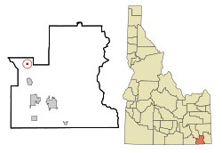
 Location in Franklin County and the state of Idaho |
|
| Coordinates: 42°15′35″N 112°1′13″W / 42.25972°N 112.02028°WCoordinates: 42°15′35″N 112°1′13″W / 42.25972°N 112.02028°W | |
| Country | United States |
| State | Idaho |
| County | Franklin |
| Area | |
| • Total | 0.25 sq mi (0.65 km2) |
| • Land | 0.25 sq mi (0.65 km2) |
| • Water | 0 sq mi (0 km2) |
| Elevation | 4,803 ft (1,464 m) |
| Population (2010) | |
| • Total | 48 |
| • Estimate (2012) | 47 |
| • Density | 192.0/sq mi (74.1/km2) |
| Time zone | Mountain (MST) (UTC-7) |
| • Summer (DST) | MDT (UTC-6) |
| Area code(s) | 208 |
| FIPS code | 16-60040 |
| GNIS feature ID | 0388063 |
Oxford is a city in Franklin County, Idaho, United States. The population was 48 at the 2010 census. It is part of the Logan, Utah-Idaho Metropolitan Statistical Area.
Oxford was first settled by Mormons in September 1864.
Oxford has several historical links. It is the location Harold B. Lee, a future president of The Church of Jesus Christ of Latter-day Saints, taught school. It is also the location where Jefferson Hunt, a Mormon colonist died. Hunt is buried just behind the hill off the highway at Red Rock Pass.
Oxford is located at 42°15′35″N 112°1′13″W / 42.25972°N 112.02028°W (42.259830, -112.020187).
According to the United States Census Bureau, the city has a total area of 0.25 square miles (0.65 km2), all of it land.
As of the census of 2010, there were 48 people, 17 households, and 11 families residing in the city. The population density was 192.0 inhabitants per square mile (74.1/km2). There were 22 housing units at an average density of 88.0 per square mile (34.0/km2). The racial makeup of the city was 93.8% White and 6.3% Native American.
...
Wikipedia
