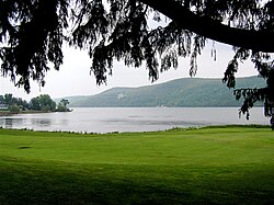
Otsego Lake (New York)
| Otsego Lake | |
|---|---|
 |
|
| Location |
Otsego County, New York, United States |
| Coordinates | 42°45′23″N 74°53′46″W / 42.7564°N 74.8961°WCoordinates: 42°45′23″N 74°53′46″W / 42.7564°N 74.8961°W |
| Primary outflows | Susquehanna River |
| Catchment area | 74 sq mi (190 km2) |
| Basin countries | United States |
| Max. length | 7.8 miles (12.6 km) |
| Surface area | 4,046 acres (16.37 km2) |
| Average depth | 82 feet (25 m) |
| Max. depth | 167 feet (51 m) |
| Surface elevation | 1,191 feet (363 m) |
| Settlements | Cooperstown, New York |
Otsego Lake is a 4,046-acre (16.37 km2) lake located in Otsego County, New York and is the source of the Susquehanna River. The Village of Cooperstown is located at the lake's southern end. Glimmerglass State Park is located on the lake's northeastern shore, and includes Hyde Hall, a large mansion constructed in 1817 that overlooks the lake. Glimmerglass Opera is located on the western shore.
The name Otsego is from a Mohawk or Oneida word meaning "place of the rock", referring to the large boulder near the lake's outlet, today known as "Council Rock".
Otsego Lake is 7.8 miles (12.6 km) long with a surface area of 4,046 acres (16.37 km2). Its average depth is 82 feet (25 m), with a maximum depth of 167 feet (51 m). Portions of the lake are within the towns of Springfield, Middlefield and Otsego.
It is geologically related to the Finger Lakes but is not counted among them. One difference is that Otsego Lake is situated at a higher elevation (1,191 feet [363 m]) than the Finger Lakes (approximately 400 feet [122 m]).
Located near the shore of Otsego Lake in Cooperstown is Council Rock, a large boulder whose top is above the water's surface and can be seen from shore. At low water, the oval rock rises approximately 4.5 feet (1.4 m) above the water, and is about nine feet (2.7 m) long by six feet (1.8 m) wide. It is believed to have been a meeting place for Native Americans prior to the American Revolutionary War.
A small parcel of land near Council Rock was presented to the Village of Cooperstown in 1957, on the condition that it remain open to the public as a park. The park, today known as Council Rock Park, also includes a set of concrete steps leading to a lake-level terrace that was built in 1937.
...
Wikipedia
