Otaki, Nagano
|
Ōtaki 王滝村 |
|||
|---|---|---|---|
| Village | |||

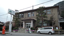
Ōtaki Village Hall
|
|||
|
|||
 Location of Ōtaki in Nagano Prefecture |
|||
| Coordinates: 35°48′33.6″N 137°33′2.7″E / 35.809333°N 137.550750°ECoordinates: 35°48′33.6″N 137°33′2.7″E / 35.809333°N 137.550750°E | |||
| Country | Japan | ||
| Region | Chūbu (Kōshin'etsu) | ||
| Prefecture | Nagano | ||
| District | Kiso | ||
| Area | |||
| • Total | 310.82 km2 (120.01 sq mi) | ||
| Population (October 2016) | |||
| • Total | 829 | ||
| • Density | 2.67/km2 (6.9/sq mi) | ||
| Time zone | Japan Standard Time (UTC+9) | ||
| Symbols | |||
| • Tree | Chamaecyparis obtusa | ||
| • Flower | Rhododendron subg. Hymenanthes | ||
| Phone number | 0264-48-2001 | ||
| Address | 3623 Kamijo, Ōtaki-mura, Kiso-gun, Nagano-ken 397-0201 | ||
| Website | www |
||
Ōtaki (王滝村 Ōtaki-mura?) is a village located in Kiso District in south-west Nagano Prefecture, in the Chūbu region of Japan. As of 1 October 2016[update], the village had an estimated population of 829 and a population density of 2.67 persons per km². Its total area was 310.82 square kilometres (120.01 sq mi). At present Ōtaki's land area is 95% forestland; 86% of which is designated national forest.
Ōtaki is located in the Kiso Mountains of southwest Nagano Prefecture, bordered by Gifu Prefecture to the west. Mount Ontake (3067 meters) is on the northern border of the village. Makio Dam is located within the village.
The area of present-day Ōtaki was part of ancient Shinano Province, and the name of Ōtaki appears in a 1504 record as part of the Chikuma region of Shinano. The modern village of Ōtaki was incorporated on April 1, 1889 by the establishment of the municipalities system.
In 1917, construction begins on the Ōtaki forest railroad (王滝 森林鉄道) The railroad was discontinued on June 30, 1975. On May 1, 1968, Chikuma District was renamed Kiso District. On September 14, 1984 the 1984 Otaki earthquake causesd section of Mount Ontake to crumble and flow into the Ōtaki Valley, with 29 people reported dead or missing and 87 homes destroyed.
...
Wikipedia


