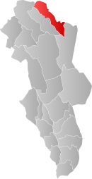
Os, Hedmark
| Os kommune | |||
|---|---|---|---|
| Municipality | |||
|
|||
 Os within Hedmark |
|||
| Coordinates: 62°28′34″N 11°14′35″E / 62.47611°N 11.24306°ECoordinates: 62°28′34″N 11°14′35″E / 62.47611°N 11.24306°E | |||
| Country | Norway | ||
| County | Hedmark | ||
| District | Østerdalen | ||
| Administrative centre | Os i Østerdalen | ||
| Government | |||
| • Mayor (2011) | Arnfinn Nergård (Sp) | ||
| Area | |||
| • Total | 1,040 km2 (400 sq mi) | ||
| • Land | 1,008 km2 (389 sq mi) | ||
| Area rank | 101 in Norway | ||
| Population (2004) | |||
| • Total | 2,131 | ||
| • Rank | 333 in Norway | ||
| • Density | 2/km2 (5/sq mi) | ||
| • Change (10 years) | 4.2 % | ||
| Demonym(s) | Osing | ||
| Time zone | CET (UTC+1) | ||
| • Summer (DST) | CEST (UTC+2) | ||
| ISO 3166 code | NO-0441 | ||
| Official language form | Neutral | ||
| Website | www |
||
|
|
|||
Os is a municipality in Hedmark county, Norway. It is part of the traditional region of Østerdalen. The administrative centre of the municipality is the village of Os i Østerdalen. The new municipality of Os was separated from Tolga on 1 July 1926. (Tolga and Os were also briefly merged from 1966-1976: see Tolga-Os.)
The municipality is located to the west of the municipality of Røros and to the south of Midtre Gauldal and Holtålen in Sør-Trøndelag county. In Hedmark county, Os is east of Tolga and north of Engerdal.
The municipality (originally the parish) is named after the old Os farm (Old Norse: Óss), since the first church was built here (in 1703). The name is identical with the word óss which means "mouth of a river" (here it is the Vangrøfta river running out into the Glomma river).
The coat-of-arms is from modern times. They were granted on 17 December 1992. The arms show three gold cowbells on a green background. It symbolizes the traditional and modern businesses in the municipality.
Lakes in the region include Flensjøen.
...
Wikipedia


