Ore mountains
| Ore Mountains | |
|---|---|
| Erzgebirge - Krušné hory | |

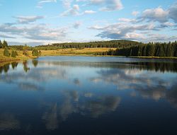
Reservoir near Myslivny
|
|
| Highest point | |
| Peak | Klínovec |
| Elevation | 1,244 m (4,081 ft) |
| Coordinates | 50°23′46″N 12°58′04″E / 50.39611°N 12.96778°E |
| Geography | |
| Countries | Czech Republic and Germany |
| States/Provinces | Karlovy Vary Region (Czech Rep.), Ústí n. L. Region (Czech Rep.) and Saxony (Germany) |
| Range coordinates | 50°35′N 13°00′E / 50.58°N 13°ECoordinates: 50°35′N 13°00′E / 50.58°N 13°E |
| Geology | |
| Orogeny | Variscan |
| Age of rock | Paleozoic |
| Type of rock | sedimentary, metamorphic and magmatic rocks |
The Ore Mountains (pronunciation: /ɔːr/) (German: Erzgebirge; Czech: Krušné hory; both literally "ore mountains") in Central Europe have formed a natural border between Saxony and Bohemia for around 800 years, from the 12th to the 20th centuries. Today, the border between Germany and the Czech Republic runs just north of the main crest of the mountain range. The highest peaks are the Klínovec (German: Keilberg), which rises to 1,244 metres (4,081 ft) above sea level and the Fichtelberg (1,215 metres (3,986 ft)).
The area played an important role in contributing Bronze Age ore, and as the setting of the earliest stages of the early modern transformation of mining and metallurgy from a craft to a large-scale industry, a process that preceded and enabled the later Industrial Revolution.
The Ore Mountains are a Hercynian block tilted so as to present a steep scarp face towards Bohemia and a gentle slope on the German side. They were formed during a lengthy process:
During the folding of the Variscan orogeny, metamorphism occurred deep underground, forming slate and gneiss. In addition, granite plutons intruded into the metamorphic rocks. By the end of the Palaeozoic era, the mountains had been eroded into gently undulating hills (the Permian massif), exposing the hard rocks.
...
Wikipedia

