Orchard, Nebraska
| Orchard, Nebraska | |
|---|---|
| Village | |

IMAC plant in Orchard. The plant produces anti-caking agents and starter media for cheese production.
|
|
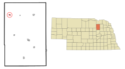
 Location of Orchard, Nebraska |
|
| Coordinates: 42°20′10″N 98°14′24″W / 42.33611°N 98.24000°WCoordinates: 42°20′10″N 98°14′24″W / 42.33611°N 98.24000°W | |
| Country | United States |
| State | Nebraska |
| County | Antelope |
| Established | 1881 |
| Area | |
| • Total | 0.45 sq mi (1.17 km2) |
| • Land | 0.45 sq mi (1.17 km2) |
| • Water | 0 sq mi (0 km2) |
| Elevation | 1,942 ft (592 m) |
| Population (2010) | |
| • Total | 379 |
| • Estimate (2016) | 349 |
| • Density | 840/sq mi (320/km2) |
| Time zone | Central (CST) (UTC-6) |
| • Summer (DST) | CDT (UTC-5) |
| ZIP code | 68764 |
| Area code(s) | 402 |
| FIPS code | 31-37210 |
| GNIS feature ID | 0831887 |
Orchard is a village in Antelope County, Nebraska, United States. The population was 379 at the 2010 census.
Orchard was founded in 1880 when the railroad was extended to that point. It took its name from local apple orchards.
Approximately one block north of Orchard Public School, there is a collection of recreational facilities, including two baseball fields, a municipal pool, a playground area, tennis court, and batting cage.
Around 2007, the villages of Clearwater, Orchard, Royal and Verdigre became the Unified School District #1 and began sharing administration between them. Subsequent to this, in 2009, presumably due to a lack of funds and a lack of student participation on both ends, school rivals, the Orchard Orioles football team, and the Clearwater Cardinals football team, combined to form the O-C Cyclones. After the initial trial year, it was decided that all sports teams between the two schools would combine under the O-C Cyclones banner. The school systems have since combined to form the Clearwater-Orchard Public Schools.
Orchard is served by the Orchard Public Library.
Orchard is located at 42°20′10″N 98°14′24″W / 42.33611°N 98.24000°W (42.336036, -98.240091).
According to the United States Census Bureau, the village has a total area of 0.45 square miles (1.17 km2), all of it land.
This climatic region is typified by large seasonal temperature differences, with warm to hot (and often humid) summers and cold (sometimes severely cold) winters. According to the Köppen Climate Classification system, Orchard has a humid continental climate, abbreviated "Dfa" on climate maps.
...
Wikipedia
