Orbe
| Orbe | ||
|---|---|---|

Orbe town
|
||
|
||
| Coordinates: 46°43′N 06°32′E / 46.717°N 6.533°ECoordinates: 46°43′N 06°32′E / 46.717°N 6.533°E | ||
| Country | Switzerland | |
| Canton | Vaud | |
| District | Jura-Nord Vaudois | |
| Government | ||
| • Mayor | Syndic | |
| Area | ||
| • Total | 12.02 km2 (4.64 sq mi) | |
| Elevation | 479 m (1,572 ft) | |
| Population (Dec 2015) | ||
| • Total | 6,852 | |
| • Density | 570/km2 (1,500/sq mi) | |
| Postal code | 1350 | |
| SFOS number | 5757 | |
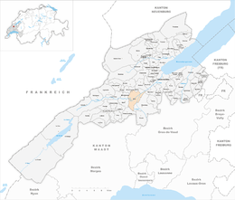
| Surrounded by | Agiez, Arnex-sur-Orbe, Chavornay, Épendes, Essert-Pittet, Mathod, Montcherand, Valeyres-sous-Rances | |
| Website |
www Profile (French), SFSO statistics |
|
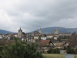
Orbe (Latin: Urba; German: Orbach) is a municipality in the Swiss canton of Vaud. It was the seat of the former district of Orbe and is now part of the district of Jura-Nord Vaudois.
Orbe is first mentioned about 280 as Urba. In 1179, it was mentioned as versus Orbam.
During the Roman era, Orbe – then known as Urba – was a town of Gallia, in the territory of the Helvetii. In the Antonine Itinerary, it is placed between Lacus Lausonius and Ariolica, xviii m.p. from Lacus Lausonius and xxiiii m.p. from Ariolica. On the Boscéaz hill, a Roman villa was built by an unknown landowner. The mosaics of the villa are still visible.
By the Middle Ages, Orbe sat on the road over the Jougne Pass and at the crossroads of two major transportation routes. One stretched from the Jura Mountains to the Alps while the other ran from the Rhine River to the Rhone River. The municipality grew up on both sides of the Orbe. On the left side was the villa Tavellis and the parish church of Saint-Germain, while the right side had the villa Tabernis with the church of Saint-Martin. At some point during the Middle Ages, a bridge was built across the river which joined the two settlements. Orbe Castle and the town's market were built on the hill above the river and the bridge.
...
Wikipedia


