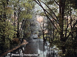
Onondaga Creek
| Onondaga Creek | |
|
Onondaga Creek about 1900
|
|
| Country | United States |
|---|---|
| State | New York |
| County | Onondaga County, New York |
| Source | |
| - location | Vesper, New York, Onondaga County, New York |
| Mouth | |
| - location | Onondaga Lake, Syracuse, Onondaga County, New York |
| - coordinates | 43°4′4″N 76°10′41″W / 43.06778°N 76.17806°WCoordinates: 43°4′4″N 76°10′41″W / 43.06778°N 76.17806°W |
| Length | 27.2 mi (44 km) |
| Basin | 111 sq mi (287 km2) |
| Discharge | for Syracuse |
| - average | 183 cu ft/s (5 m3/s) |
| - max | 2,040 cu ft/s (58 m3/s) |
| - min | 23 cu ft/s (1 m3/s) |
|
Onondaga Creek watershed
|
|
Onondaga Creek is a major tributary of Onondaga Lake which is located in Onondaga County, New York. The headwaters of the creek originate 27 miles (43 km) south of the city of Syracuse near the hamlet of Vesper, in the town of Tully, New York. The creek flows north through the Tully Valley and through the city of Syracuse where it empties into Onondaga Lake.
The major tributaries of Onondaga Creek are the West Branch of Onondaga Creek, Hemlock Creek and Rattlesnake Gulf. The watershed consists of "mixed land use of about 80% forest, rural, and agriculture, and 20% urban".
Onondaga Creek contributes approximately 30 to 40 percent of the total inflow to Onondaga Lake. Water quality in the creek has been a concern "historically with regards to its impacts" on the lake.
At its mouth, Onondaga Creek is enriched with nutrients and suspended sediment. These problems are magnified at high flows. Near the mouth, groundwater springs continuously discharge brackish (salty) water into the creek. The creek is the largest source of sediment in Onondaga Lake.
In the late 1940s, the Army Corp. of Engineers built a flood control dam and reservoir within the Onondaga Nation Reservation for the purpose of regulating the peak flow that reaches the city of Syracuse. The structure influences the creek's flow pattern only in the event of a large runoff when a portion of very high flow is stored in the reservoir and later released back into the creek when the water recedes.
...
Wikipedia


