Omega (navigation system)
| Paynesville Omega Mast | |
|---|---|
| General information | |
| Status | Demolished |
| Type | Guyed grounded mast equipped with umbrella antenna |
| Location | Paynesville, Liberia |
| Coordinates | 06°18′20″N 010°39′44″W / 6.30556°N 10.66222°W |
| Completed | 1976 |
| Destroyed | May 10, 2011 |
| Height | 417 m (1,368.11 ft) |
| Design and construction | |
| Main contractor | US Coast Guard |
| La Moure Omega Mast | |
|---|---|
| General information | |
| Status | Complete |
| Type | Mast radiator insulated against ground |
| Location | La Moure, North Dakota, United States |
| Coordinates | 46°21′57″N 098°20′08″W / 46.36583°N 98.33556°W |
| Height | 365.25 m (1,198.33 ft) |
| Design and construction | |
| Main contractor | US Coast Guard |
| Chabrier Omega Mast | |
|---|---|
| General information | |
| Status | Destroyed |
| Type | Guyed grounded mast equipped with umbrella antenna |
| Location | Chabrier, Réunion |
| Coordinates | 20°58′27″S 55°17′24″E / 20.97417°S 55.29000°E |
| Completed | 1976 |
| Destroyed | April 14th, 1999 |
| Height | 428 m (1,404.20 ft) |
| Design and construction | |
| Main contractor | US Coast Guard |
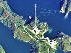
| Omega Mast, Tsushima | |
|---|---|

Made based on National Land Image Information (Color Aerial Photographs), Ministry of Land, Infrastructure, Transport and Tourism.
|
|
| General information | |
| Status | Destroyed |
| Type | Mast radiator insulated against ground |
| Location | Tsushima, Japan |
| Coordinates | 34°36′53″N 129°27′13″E / 34.61472°N 129.45361°E |
| Completed | 1973 |
| Destroyed | 1998 |
| Height | 455 m (1,492.78 ft) |
| Design and construction | |
| Main contractor | US Coast Guard |
OMEGA was the first truly global-range radio navigation system, operated by the United States in cooperation with six partner nations. It enabled ships and aircraft to determine their position by receiving very low frequency (VLF) radio signals in the range 10 to 14 kHz, transmitted by a network of fixed terrestrial radio beacons, using a receiver unit. It became operational around 1971 and was shut down in 1997 in favour of the Global Positioning Satellite system.
Taking a "fix" in any navigation system requires the determination of two measurements. Typically these are taken in relation to fixed objects like prominent landmarks or the known location of radio transmission towers. By measuring the angle to two such locations, the position of the navigator can be determined. Alternately, one can measure the angle and distance to a single object, or the distance to two objects.
The introduction of radio systems during the 20th century dramatically increased the distances over which measurements could be taken. Such a system also demanded much greater accuracies in the measurements – an error of one degree in angle might be acceptable when taking a fix on a lighthouse a few miles away, but would be of limited use when used on a radio station 300 miles (480 km) away. A variety of methods were developed to take fixes with relatively small angle inaccuracies, but even these were generally useful only for short-range systems.
The same electronics that made basic radio systems work introduced the possibility of making very accurate time delay measurements. This enabled accurate measurement of the delay between the transmission and reception of the signal. The delay measurement could be used to determine the distance between the two transmitters. The problem was knowing when the transmission was initiated. With radar, this was simple, as the transmitter and receiver were usually at the same location. Measuring the delay between sending the signal and receiving the echo allowed accurate range measurement.
For other uses, air navigation for instance, the receiver would have to know the precise time the signal was transmitted. This was not generally possible using electronics of the day. Instead, two stations were synchronized by using one of the two transmitted signals as the trigger for the second signal. By comparing the measured delay between the two signals, and comparing that with the known delay, the aircraft's position was revealed to lie along a curved line in space. By making two such measurements against widely separated stations, the resulting lines would overlap in two locations. These locations were normally far enough apart to allow conventional navigation systems, like dead reckoning, to eliminate the incorrect position solution.
...
Wikipedia
