Olivier-Charbonneau Bridge
| Olivier Charbonneau Bridge | |
|---|---|

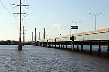
The A25 Bridge connecting Montreal and Laval, Quebec.
|
|
| Coordinates | 45°38′16″N 73°37′14″W / 45.63778°N 73.62056°W |
| Carries | Six lanes of |
| Crosses | Rivière des Prairies |
| Locale | between Laval (Duvernay district) and Montreal (Rivière-des-Prairies–Pointe-aux-Trembles) |
| Official name | Pont Olivier-Charbonneau |
| History | |
| Opened | May 21, 2011 |
| Statistics | |
| Daily traffic | 36,400 (2013) |
| Toll | $2.20-$3.16 with transponder, add $5.26 with picture |
Coordinates: 45°38′16″N 73°37′14″W / 45.63778°N 73.62056°W
The Olivier Charbonneau Bridge is a toll bridge over the Rivière des Prairies, between Laval's Duvernay district and Montreal's Rivière-des-Prairies–Pointe-aux-Trembles borough. Along with the , it is one of two toll bridges in Quebec.
Before May 2012, the bridge was called the A25 Bridge. It was then renamed to commemorate Olivier Charbonneau (1613-1687), French frontiersman and first inhabitant of Île Jésus, where the city of Laval now stands.
The Olivier Charbonneau Bridge was part of a 7.2 km (4.5 mi)-long project for the completion of Highway 25, and allows cars, trucks and buses to avoid the Pie IX Bridge upstream. It also provides a route around the city of Montreal by connecting Louis Hippolyte Lafontaine Tunnel to Highway 440, thus allowing motorists to avoid the congested Metropolitan Expressway. It is the second modern toll bridge built in Quebec and the first ever built in the Montreal Metropolitan Area since the abolition of toll fares on Champlain bridge in 1990.
...
Wikipedia
