Oklahoma State Highway 59
| State Highway 59 | ||||
|---|---|---|---|---|
 |
||||
| Route information | ||||
| Maintained by ODOT | ||||
| Length: | 93.0 mi (149.7 km) | |||
| Existed: | 1932 – present | |||
| Major junctions | ||||
| West end: |
|
|||
| East end: |
|
|||
| Highway system | ||||
|
Oklahoma State Highway System
|
||||
| State Highway 59A | |
|---|---|
| Location: | McClain and counties |
| Length: | 5.27 mi (8.48 km) |
| State Highway 59B | |
|---|---|
| Location: | Garvin and McClain counties |
| Length: | 5.69 mi (9.16 km) |
| State Highway 59B | |
|---|---|
| Location: | Macomb |
| Length: | 6.93 mi (11.15 km) |
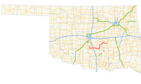
State Highway 59, abbreviated SH-59, is a 93-mile (150 km) state highway in central Oklahoma. It runs from Criner, Oklahoma in McClain Co. to Wewoka.
SH-59 begins at SH-39 north of Criner and immediately heads due south through that town. It turns due east six miles (9.6 km) north of Lindsay, serving Payne instead. After a one-mile (1.6 km) concurrency with SH-24, SH-59 crosses SH-74 and has an interchange with I-35.
Shortly after passing under the interstate, it meets US-77 south of Wayne, and passes through the small towns of Rosedale and Byars. Five miles (8 km) east of Byars, it meets U.S. Highway 177 and turns northward to join with it. SH-3W joins the concurrency five miles later.
The three highways cross over the South Canadian River to enter Pottawatomie Co. just south of Asher. In Asher, SH-59 meets SH-39 a second time, and six miles (10 km) later it splits off from US-177 and SH-3W to head east again, through St. Louis, Oklahoma and Maud. It forms a concurrency with US-377/SH-99/SH-3E south of Seminole, before splitting off near Bowlegs. It meets US-270 west of Wewoka, and then ends two miles (3 km) later.
...
Wikipedia

