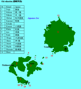
Oki Islands
| Native name: 隠岐諸島 | |
|---|---|
 |
|
| Map of the Oki Islands | |
| Geography | |
| Coordinates | 36°10′16.1″N 133°8′40.8″E / 36.171139°N 133.144667°ECoordinates: 36°10′16.1″N 133°8′40.8″E / 36.171139°N 133.144667°E |
| Adjacent bodies of water | Sea of Japan |
| Total islands | 4 main, 16 named, 180+ total |
| Area | 346.1 km2 (133.6 sq mi) |
| Administration | |
| Prefectures | Shimane |
| District | Oki District |
| Demographics | |
| Population | 24,500 (2010) |
| Pop. density | 70.7 /km2 (183.1 /sq mi) |
| Ethnic groups | Japanese |
| Chibu | ||||||||||||||||||||||||||||||||||||||||||||||||||||||||||||
|---|---|---|---|---|---|---|---|---|---|---|---|---|---|---|---|---|---|---|---|---|---|---|---|---|---|---|---|---|---|---|---|---|---|---|---|---|---|---|---|---|---|---|---|---|---|---|---|---|---|---|---|---|---|---|---|---|---|---|---|---|
| Climate chart () | ||||||||||||||||||||||||||||||||||||||||||||||||||||||||||||
|
||||||||||||||||||||||||||||||||||||||||||||||||||||||||||||
|
||||||||||||||||||||||||||||||||||||||||||||||||||||||||||||
| J | F | M | A | M | J | J | A | S | O | N | D |
|
116
8
2
|
96
7
1
|
104
11
3
|
105
16
7
|
131
20
12
|
172
24
17
|
227
27
21
|
124
29
23
|
211
25
18
|
107
20
12
|
122
15
7
|
124
11
4
|
| Average max. and min. temperatures in °C | |||||||||||
| Precipitation totals in mm | |||||||||||
| Source: | |||||||||||
| Imperial conversion | |||||||||||
|---|---|---|---|---|---|---|---|---|---|---|---|
| J | F | M | A | M | J | J | A | S | O | N | D |
|
4.5
46
35
|
3.8
45
34
|
4.1
51
37
|
4.1
60
45
|
5.2
68
54
|
6.8
74
62
|
8.9
80
71
|
4.9
84
73
|
8.3
77
64
|
4.2
69
53
|
4.8
60
45
|
4.9
51
39
|
| Average max. and min. temperatures in °F | |||||||||||
| Precipitation totals in inches | |||||||||||
...
Wikipedia

