Okeechobee County
| Okeechobee County, Florida | ||
|---|---|---|
| County | ||
| County of Okeechobee | ||

The Okeechobee County Judicial Center, in Okeechobee
|
||
|
||
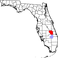
 Location in the U.S. state of Florida |
||
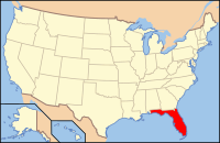
 Florida's location in the U.S. |
||
| Founded | May 8, 1915 | |
| Named for | Lake Okeechobee | |
| Seat | Okeechobee | |
| Largest city | Okeechobee | |
| Area | ||
| • Total | 892 sq mi (2,310 km2) | |
| • Land | 769 sq mi (1,992 km2) | |
| • Water | 123 sq mi (319 km2), 13.8% | |
| Population (est.) | ||
| • (2015) | 39,469 | |
| • Density | 52/sq mi (20/km²) | |
| Congressional district | 17th | |
| Time zone | Eastern: UTC-5/-4 | |
| Website | www |
|
Okeechobee County (US /oʊkiˈtʃoʊbi/) is a county located in the state of Florida. As of the 2010 census, the population was 39,996. The county seat is Okeechobee.
Okeechobee County comprises the Okeechobee, FL Micropolitan Statistical Area, which is included in the Miami-Fort Lauderdale-Port St. Lucie, FL Combined Statistical Area.
Okeechobee County was incorporated in 1917. It was named for the Lake Okeechobee, which was itself named for Hitchiti words oka (water) and chobi (big).
Historic buildings in Okeechobee County include:
According to the U.S. Census Bureau, the county has a total area of 892 square miles (2,310 km2), of which 769 square miles (1,990 km2) is land and 123 square miles (320 km2) (13.8%) is water.
The Lake Okeechobee Scenic Trail, part of the Florida National Scenic Trail, runs along the Herbert Hoover Dike around the Lake.
...
Wikipedia

