Oirschot
| Oirschot | |||
|---|---|---|---|
| Municipality | |||

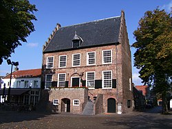
Former city hall of Oirschot
|
|||
|
|||
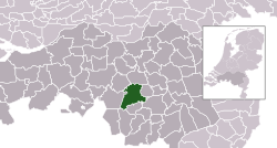
 Location in North Brabant |
|||
| Coordinates: 51°30′N 5°18′E / 51.500°N 5.300°ECoordinates: 51°30′N 5°18′E / 51.500°N 5.300°E | |||
| Country | Netherlands | ||
| Province | North Brabant | ||
| Government | |||
| • Body | Municipal council | ||
| • Mayor | Ruud Severijns (PvdA) | ||
| Area | |||
| • Total | 102.84 km2 (39.71 sq mi) | ||
| • Land | 101.78 km2 (39.30 sq mi) | ||
| • Water | 1.06 km2 (0.41 sq mi) | ||
| Elevation | 17 m (56 ft) | ||
| Population (May 2014) | |||
| • Total | 18,016 | ||
| • Density | 177/km2 (460/sq mi) | ||
| Demonym(s) | Oirschottenaar | ||
| Time zone | CET (UTC+1) | ||
| • Summer (DST) | CEST (UTC+2) | ||
| Postcode | 5090–5091, 5688–5689 | ||
| Area code | 013, 0499 | ||
| Website | www |
||
Oirschot (Dutch pronunciation: [ˈoːrsxɔt]; dialect: Orskot) is a municipality and a town in the southern Netherlands. It is situated 12 kilometres (7.5 mi) from the city of Eindhoven and 20 kilometres (12 mi) from the city of Tilburg in the province Noord-Brabant (North Brabant). The municipality had a population of 18,016 in 2014.
Dutch Topographic map of the municipality of Oirschot, June 2015
Oirschot, windmill: windmolen de Korenaar
Oirschot, Jumbo supermarket
Oirschot, sculpture near de Sint Jorisstraat
Oostelbeers, tower: de Heilige Andreas en Antonius van Paduatoren
Spoordonk, church: de Bernadettekerk
There are more than 300 monuments in the municipality Oirschot. Some of the monuments are:
There are many more festivals in Oirschot every year.
City Council
The municipal elections in March 2014 resulted in the following make-up of the City Council (17 seats in total):
Mayor
The mayor of the municipality Oirschot is named Ruud Severijns. He is member of the political party PvdA.
...
Wikipedia


