Odenton, Maryland
| Odenton, Maryland | |
|---|---|
| Census-designated place | |

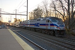
A MARC Penn Line train pulls out of Odenton station while an Northeast Regional train pulled by an AEM-7 passes through.
|
|
| Nickname(s): The city on the railroad | |
| Motto: The City a Railroad Built, The ever-growing city | |
 Location of Odenton, Maryland |
|
| Coordinates: 39°4′17″N 76°41′59″W / 39.07139°N 76.69972°WCoordinates: 39°4′17″N 76°41′59″W / 39.07139°N 76.69972°W | |
| Country | |
| State |
|
| County |
|
| Founded | 1868 |
| Area | |
| • Total | 14.8 sq mi (38.3 km2) |
| • Land | 14.8 sq mi (38.3 km2) |
| • Water | 1.2 sq mi (3.1 km2) |
| Elevation | 90 ft (48 m) |
| Population (2010) | |
| • Total | 37,132 |
| • Density | 2,513/sq mi (970.3/km2) |
| Time zone | Eastern (EST) (UTC-5) |
| • Summer (DST) | EDT (UTC-4) |
| ZIP code | 21113 |
| Area code(s) | 240, 301, 410, 443 |
| FIPS code | 24-58300 |
| GNIS feature ID | 0590935 |
Odenton (OH-dən-tən) is a census-designated place (CDP) in Anne Arundel County, Maryland, United States, located about 10–20 minutes from the state capital, Annapolis. The population was 37,132 at the 2010 census, up from 20,534 at the 2000 census. The town's population growth rate of 80.8% between 2000 and 2010 was the greatest of any town in western Anne Arundel County. Odenton is located west of Annapolis, south of Baltimore, and east of Washington, D.C.
In recent years, Odenton has become the fastest-growing city in the county with 2010 census numbers reporting 42% growth. This is because of its proximity to Fort George G. Meade, NSA headquarters and Annapolis, as well as its proximity to Baltimore, and Washington D.C. The development has been fueled by the construction of the massive Piney Orchard development as well as progress in the ongoing development of Odenton Town Center.
The town is named after former Governor of Maryland Oden Bowie. It is bordered by Gambrills to the east, Severn to the north, Fort Meade to the west, and Crofton to the south. It is located at the intersection of Maryland routes 170 and 175 and is bordered by Route 32 to the north. The zipcode is 21113.
...
Wikipedia
