Odanak
| Odanak | |
|---|---|
| First Nations reserve | |

Saint-François-de-Sales church
|
|
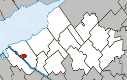
 Location within Nicolet-Yamaska RCM. |
|
| Location in southern Quebec. | |
| Coordinates: 46°04′N 72°50′W / 46.067°N 72.833°WCoordinates: 46°04′N 72°50′W / 46.067°N 72.833°W | |
| Country |
|
| Province |
|
| Region | Centre-du-Québec |
| RCM | None |
| Constituted | unspecified |
| Government | |
| • Type | Band council |
| • Federal riding | Bas-Richelieu—Nicolet—Bécancour |
| • Prov. riding | Nicolet-Bécancour |
| Area | |
| • Total | 5.70 km2 (2.20 sq mi) |
| • Land | 5.70 km2 (2.20 sq mi) |
| Population (2011) | |
| • Total | 457 |
| • Density | 80.2/km2 (208/sq mi) |
| • Dwellings | 219 |
| Time zone | EST (UTC−5) |
| • Summer (DST) | EDT (UTC−4) |
| Area code(s) | 450 |
| Access Routes |
|
Odanak is an Abenaki First Nations reserve in the Centre-du-Québec region, Quebec, Canada. The mostly First Nations population as of the Canada 2006 Census was 469. The territory is located near the mouth of the Saint-François River at its confluence with the St. Lawrence River. It is partly within the limits of Pierreville and across the river from Saint-François-du-Lac. Odanak is an Abenaki word meaning "in the village".
Beginning about 1000 CE, Iroquoian-speaking people settled along the St. Lawrence River, where they practiced agriculture along with hunting and fishing. Archeological surveys have revealed that by 1300, they built fortified villages similar to those seen and described by French explorer Jacques Cartier in the mid-16th century, when he visited Hochelaga and Stadacona. By 1600, however, the villages and people were gone. Since the 1950s, historians and anthropologists have used archeological and linguistic evidence to develop a consensus that the people formed a distinct ethnic group, whom they have called St. Lawrence Iroquoians. They spoke Laurentian and were separate from the powerful Iroquois confederacy of nations that developed in present-day New York and Pennsylvania along the southern edges of the Great Lakes.
...
Wikipedia

