Oconto, Nebraska
| Oconto, Nebraska | |
|---|---|
| Village | |

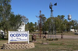
Oconto welcome sign, windmill, and sculptures
|
|
 Location of Oconto, Nebraska |
|
| Coordinates: 41°8′30″N 99°45′41″W / 41.14167°N 99.76139°WCoordinates: 41°8′30″N 99°45′41″W / 41.14167°N 99.76139°W | |
| Country | United States |
| State | Nebraska |
| County | Custer |
| Area | |
| • Total | 0.20 sq mi (0.52 km2) |
| • Land | 0.20 sq mi (0.52 km2) |
| • Water | 0 sq mi (0 km2) |
| Elevation | 2,575 ft (785 m) |
| Population (2010) | |
| • Total | 151 |
| • Estimate (2012) | 149 |
| • Density | 755.0/sq mi (291.5/km2) |
| Time zone | Central (CST) (UTC-6) |
| • Summer (DST) | CDT (UTC-5) |
| ZIP code | 68860 |
| Area code(s) | 308 |
| FIPS code | 31-35665 |
| GNIS feature ID | 0831827 |
Oconto is a village in Custer County, Nebraska, United States. The population was 151 at the 2010 census.
The community was founded in 1887, but was originally called "Olax." The current name was adopted because the original name conflicted with another Nebraska location. Some hold Oconto was the name of a pioneer settler, while others believe the town was named after Oconto, Wisconsin. Oconto was incorporated in 1906.
Oconto is located at 41°8′30″N 99°45′41″W / 41.14167°N 99.76139°W (41.141560, -99.761457).
According to the United States Census Bureau, the village has a total area of 0.20 square miles (0.52 km2), all of it land.
Oconto is located at the junction of state highways 21 and 40. It is south of the Pressey Wildlife Management area.
As of the census of 2010, there were 151 people, 68 households, and 40 families residing in the village. The population density was 755.0 inhabitants per square mile (291.5/km2). There were 82 housing units at an average density of 410.0 per square mile (158.3/km2). The racial makeup of the village was 96.0% White, 0.7% from other races, and 3.3% from two or more races. Hispanic or Latino of any race were 4.0% of the population.
...
Wikipedia
