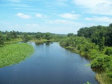
Ocklawaha River
| Ocklawaha River | |
|---|---|

Looking north on CR 42
|
|

Ocklawaha River map
|
|
| Country | United States |
| State | Florida |
| Basin features | |
| Main source | Harris chain of lakes 0 ft (0 m) |
| River mouth | St. Johns River |
| Physical characteristics | |
| Length | 74 mi (119 km) |
The 74-mile-long (119 km)Ocklawaha River flows north from central Florida until it joins the St. Johns River near Palatka. Its name is a corruption of ak-lowahe, Creek for "muddy".
The historical and original source of the Ocklawaha River is Lake Griffin, part of the Harris chain of lakes in Lake County, Florida. The river now receives discharge from the entire Harris Chain of Lakes, including Lake Eustis, Lake Harris, Lake Dora, Lake Beauclair and Lake Apopka, via a series of man-made canals and natural waterways including Haynes Creek, the Dead River, the Dora Canal, and the Apopka-Beauclair Canal. The addition of the man-made canals has increased both the discharge flow and amount of runoff pollution carried into the river. The Ocklawaha River watershed includes parts of the Green Swamp, most of Lake County, and portions of Marion, Alachua and Putnam counties. The largest of several large lakes in the Ocklawaha's watershed is the badly polluted Lake Apopka near Orlando.
The Ocklawaha River is the principal tributary of the St. Johns River. The most important and well-known tributary of the Ocklawaha is the Silver River, which carries the discharge from Silver Springs. Another important tributary of the Ocklawaha is Orange Creek, which originates from Orange Lake, which is fed by Lochloosa Lake via Cross Creek and by Newnans Lake, via the Prairie Creek. From Prairie Creek, only half of its water is artificially diverted towards Orange Lake via the Camps Canal, the rest flows to its historic destination, Paynes Prairie.
...
Wikipedia
