Oberwörresbach
| Oberwörresbach | ||
|---|---|---|
|
||
| Coordinates: 49°46′50″N 07°19′14″E / 49.78056°N 7.32056°ECoordinates: 49°46′50″N 07°19′14″E / 49.78056°N 7.32056°E | ||
| Country | Germany | |
| State | Rhineland-Palatinate | |
| District | Birkenfeld | |
| Municipal assoc. | Herrstein | |
| Government | ||
| • Mayor | Heidemarie Juchum | |
| Area | ||
| • Total | 1.40 km2 (0.54 sq mi) | |
| Elevation | 346 m (1,135 ft) | |
| Population (2015-12-31) | ||
| • Total | 139 | |
| • Density | 99/km2 (260/sq mi) | |
| Time zone | CET/CEST (UTC+1/+2) | |
| Postal codes | 55758 | |
| Dialling codes | 06785 | |
| Vehicle registration | BIR | |
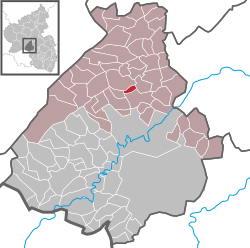
Oberwörresbach is an Ortsgemeinde – a municipality belonging to a Verbandsgemeinde, a kind of collective municipality – in the Birkenfeld district in Rhineland-Palatinate, Germany. It belongs to the Verbandsgemeinde of Herrstein, whose seat is in the like-named municipality.
The municipality lies between the southern edge of the Hunsrück and the mountain range of volcanic origin of the Upper Nahe. The village itself lies on the namesake brook, the Wörresbach. Idar-Oberstein lies 10 km away.
Oberwörresbach borders in the east on the municipality of Herrstein, in the southeast on the municipality of Niederwörresbach, in the southwest on the municipality of Herborn and in the northwest on the municipality of Mörschied.
In 1453, Oberwörresbach had its first documentary mention. It is believed, however, that there was a village here as early as 1259. The part of the village on the Wörresbach’s left bank was held by the County of Sponheim, to which the Amt of Herrstein also belonged, and the part over on the right bank was held by the Vögte of Hunolstein. Both these noble houses are reflected by today’s civic coat of arms.
An important event in the village’s history came to pass in 1933 after the Nazis came to power in the Free State of Oldenburg (this was even before Adolf Hitler’s official seizure of power that same year). One of the new government’s first initiatives was administrative reform for Oldenburg, which was followed on 27 April 1933 by the similar Gesetz zur Vereinfachung und Verbilligung der Verwaltung (“Law for simplifying administration and reducing its cost”) for the Landesteil of Birkenfeld (Oldenburg’s exclave in the Hunsrück; most of Oldenburg’s territory was in what is now northwest Germany, with a coastline on the North Sea). Through this new law, 18 formerly self-administering municipalities were amalgamated; this included Oberwörresbach, which hitherto had been a self-administering municipality. Nonetheless, it was unceremoniously made part of the municipality of Herrstein.
...
Wikipedia


