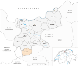
Oberhof, Switzerland
| Oberhof | ||
|---|---|---|
 |
||
|
||
| Coordinates: 47°27′N 8°0′E / 47.450°N 8.000°ECoordinates: 47°27′N 8°0′E / 47.450°N 8.000°E | ||
| Country | Switzerland | |
| Canton | Aargau | |
| District | Laufenburg | |
| Area | ||
| • Total | 8.21 km2 (3.17 sq mi) | |
| Elevation | 472 m (1,549 ft) | |
| Population (Dec 2015) | ||
| • Total | 599 | |
| • Density | 73/km2 (190/sq mi) | |
| Postal code | 5062 | |
| SFOS number | 4173 | |
| Surrounded by | Densbüren, Erlinsbach, Kienberg (SO), Küttigen, Wölflinswil | |
| Website |
www SFSO statistics |
|
Oberhof is a municipality in the district of Laufenburg in the canton of Aargau in Switzerland.
Oberhof is first mentioned in 1630 as Oberhoff. Oberhof was initially part of the municipality of Wölflinswil. From 1408 until 1797 they were part of the Habsburg District of Rheinfelden. In 1797, Oberhof became part of the French protectorate of Fricktal. Then in 1802 it joined the Canton of Fricktal, which became part of the new Canton of Aargau in 1803. When Oberhof joined Aargau, it was separated from Wölflinswil and joined as a separate municipality.
Ecclesiastically, Oberhof has remained part of the parish of Wöflinswil. In 1818, the chapel of St. Joseph (with a late baroque altar) was built. The chapel was renovated in 1975.
Oberhof has an area, as of 2009[update], of 8.21 square kilometers (3.17 sq mi). Of this area, 4.28 km2 (1.65 sq mi) or 52.1% is used for agricultural purposes, while 3.4 km2 (1.3 sq mi) or 41.4% is forested. Of the rest of the land, 0.48 km2 (0.19 sq mi) or 5.8% is settled (buildings or roads).
Of the built up area, housing and buildings made up 2.3% and transportation infrastructure made up 3.3%. Out of the forested land, 39.0% of the total land area is heavily forested and 2.4% is covered with orchards or small clusters of trees. Of the agricultural land, 17.7% is used for growing crops and 30.2% is pastures, while 4.3% is used for orchards or vine crops.
The municipality is located in the Laufenburg district, in the upper Fricktal (Frick river valley) and is on the Benkerjoch Pass road. It consists of the haufendorf village (an irregular, unplanned and quite closely packed village, built around a central square) of Oberhof and the hamlets of Benken (joined the municipality in 1827) as well as several scattered farm houses.
...
Wikipedia


