Oakley, California
| City of Oakley | ||
|---|---|---|
| City | ||

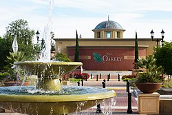
Oakley City Hall
|
||
|
||
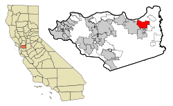
 Location in Contra Costa County and the state of California |
||
| Location in the United States | ||
| Coordinates: 37°59′51″N 121°42′45″W / 37.99750°N 121.71250°WCoordinates: 37°59′51″N 121°42′45″W / 37.99750°N 121.71250°W | ||
| Country |
|
|
| State |
|
|
| County | Contra Costa | |
| Incorporated | July 1, 1999 | |
| Government | ||
| • Mayor | Kevin Romick | |
| • State Senator | Steve Glazer (D) | |
| • State Assembly | Jim Frazier (D) | |
| • U. S. Congress | Jerry McNerney (D) | |
| Area | ||
| • Total | 16.155 sq mi (41.842 km2) | |
| • Land | 15.853 sq mi (41.059 km2) | |
| • Water | 0.302 sq mi (0.783 km2) 1.87% | |
| Elevation | 20 ft (6 m) | |
| Population (2010) | ||
| • Total | 35,432 | |
| • Density | 2,200/sq mi (850/km2) | |
| Time zone | PST (UTC-8) | |
| • Summer (DST) | PDT (UTC-7) | |
| ZIP code | 94561 | |
| Area code(s) | 925 | |
| FIPS code | 06-53070 | |
| GNIS feature IDs | 277567, 2411294 | |
| Website | www |
|
Oakley is a city in Contra Costa County, California, United States. It is within the nine-county San Francisco Bay Area. The January 1, 2016 population was 40,144, as determined by the State Department of Finance. Oakley was incorporated in 1999 and is the most recently incorporated city in Contra Costa County. Oakley is part of the East Contra Costa Bicycle Plan, which has existing facilities in Oakley as well as plans for further expansion.
The name "oak" comes from the abundance of oak trees, while the suffix "-ley" comes from the Old English word for "field" or "meadow".
The Oakley areas offers access to the Delta de Anza Regional Trail. According to reports provided by CNN, Oakley experiences 21.16 inches of annual rainfall with an average high temperature in July of 96.0 F and an average low temperature in January of 40.0 F. Oakley experiences 52% clear days throughout the year.
Oakley's west border is Highway 160, which provides access to Oakland, San Francisco, San Jose, Sacramento, and the Central Valley. The City of Antioch adjoins Oakley on the west, the city of Brentwood adjoins Oakley on the south, and Bethel Island lies to the east. The Sacramento-San Joaquin Delta forms the northern boundary. The southwestern skyline is dominated by Mt. Diablo.
Prior to 1963, creating a new city in California only required a petition, a public hearing (where 51 percent of the landowners could approve the desire to incorporate) and an election. During the 1950s over 50 new cities incorporated, and in Los Angeles County alone, 10 new cities incorporated in 1957. At the time, no thought was given as to how or who would pay the costs for the necessary services needed to sustain a city. Fire, police, water and sanitation services were often provided by a number of different and overlapping entities.
In an effort to gain control over this kluge of overlapping services and control the proliferation of incorporations, Governor Edmund G Brown, Sr. created the Commission on Metropolitan Area Problems, in 1959. The Commission was given the task of studying and making recommendations on the "misuse of land resources" and the growing complexity of overlapping local government jurisdictions.
...
Wikipedia

