Oakland, New Jersey
| Oakland, New Jersey | |
|---|---|
| Borough | |
| Borough of Oakland | |

|
|
 Map highlighting Oakland's location within Bergen County. Inset: Bergen County's location within New Jersey. |
|
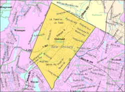
 Census Bureau map of Oakland, New Jersey |
|
| Coordinates: 41°01′48″N 74°14′38″W / 41.02998°N 74.243842°WCoordinates: 41°01′48″N 74°14′38″W / 41.02998°N 74.243842°W | |
| Country | |
| State |
|
| County | Bergen |
| Incorporated | April 8, 1902 |
| Government | |
| • Type | Borough |
| • Body | Borough Council |
| • Mayor | Linda H. Schwager (D, term ends December 31, 2019) |
| • Administrator | Richard Kunze |
| • Clerk | Lisa M. Duncan |
| Area | |
| • Total | 8.728 sq mi (22.605 km2) |
| • Land | 8.454 sq mi (21.897 km2) |
| • Water | 0.274 sq mi (0.709 km2) 3.13% |
| Area rank | 222nd of 566 in state 5th of 70 in county |
| Elevation | 233 ft (71 m) |
| Population (2010 Census) | |
| • Total | 12,754 |
| • Estimate (2015) | 13,165 |
| • Rank | 190th of 566 in state 25th of 70 in county |
| • Density | 1,508.6/sq mi (582.5/km2) |
| • Density rank | 335th of 566 in state 64th of 70 in county |
| Time zone | Eastern (EST) (UTC-5) |
| • Summer (DST) | Eastern (EDT) (UTC-4) |
| ZIP code | 07436 |
| Area code(s) | 201 |
| FIPS code | 3400353850 |
| GNIS feature ID | 0885330 |
| Website | oakland-nj |
Oakland is a borough in Bergen County, New Jersey, United States. As of the 2010 United States Census, the borough's population was 12,754, reflecting an increase of 288 (+2.3%) from the 12,466 counted in the 2000 Census, which had in turn increased by 469 (+3.9%) from the 11,997 counted in the 1990 Census.
Oakland was incorporated as a borough by an act of the New Jersey Legislature on April 8, 1902, from portions of Franklin Township (now Wyckoff). The name comes from the white oak trees in the area.
The Van Allen House was built in 1748 and was a stop for George Washington and his troops in 1777.
From the 1940s through the end of the 1960s a summer bungalow colony was developed in a valley in West Oakland on the Ramapo River. This was a refuge for a close-knit group of several score families from the summer heat of New York City and urban New Jersey. During the summer months the New York, Susquehanna and Western Railroad provided service at a West Oakland passenger station. This colony was located on the road between Oakland and Pompton Lakes, near a training camp for boxers. In the early morning, a resident could see Joe Louis or Sugar Ray Robinson, among others, running past the summer homes.
One section of streets in the town are named after Native American tribes and Native American first names. Now considered politically incorrect, the borough had a wooden sign posted downtown that read "Once there was [sic] Indians all over this place" which had been donated by a resident who insisted on the wording of the sign as having been a quotation from an author.
...
Wikipedia
