Nyngan
|
Nyngan New South Wales |
|||||||
|---|---|---|---|---|---|---|---|

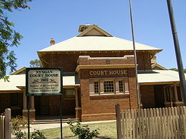
Court house, Nyngan
|
|||||||
| Coordinates | 31°34′0″S 147°12′0″E / 31.56667°S 147.20000°ECoordinates: 31°34′0″S 147°12′0″E / 31.56667°S 147.20000°E | ||||||
| Population | 2,073 (2011 census) | ||||||
| Postcode(s) | 2825 | ||||||
| Elevation | 173 m (568 ft) | ||||||
| Location | |||||||
| LGA(s) | Bogan Shire | ||||||
| County | Oxley | ||||||
| State electorate(s) | Barwon | ||||||
| Federal Division(s) | Parkes | ||||||
|
|||||||
Nyngan [pr: ning-gan] is a town in the centre of New South Wales, Australia, in the Bogan Shire local government area within the Orana Region of central New South Wales. At the 2011 census, Nyngan had a population of 2,073 people. Nyngan is situated on the Bogan River between Narromine and Bourke, on the junction of the Mitchell Highway and Barrier Highway, 583 km north-west of Sydney by road. The Barrier Highway starts at Nyngan, and runs west to Cobar and on through Wilcannia and Broken Hill into South Australia.
Nyngan Airport is a small airport just north of the town centre. Nyngan also lies on the Main Western railway line of New South Wales but is no longer served by passenger trains. The line remains open to freight traffic.
About 70 kilometres south of the town a cairn has been erected in honour of Thurman the dog.
The district was originally inhabited by the Ngiyambaa Aborigines. Thomas Mitchell explored the Bogan River in 1835, camping on the future townsite. He recorded the local Aboriginal word nyingan, said to mean 'long pond of water', though other meanings have been put forward, such as mussel or crayfish. Squatters had settled in Mitchell's wake before he had begun his return journey. The town flourished after completion of the railway line in 1883.
...
Wikipedia

