Nyírség
|
Szabolcs-Szatmár-Bereg County Szabolcs-Szatmár-Bereg megye (Hungarian) |
|||
|---|---|---|---|
| Counties of Hungary | |||
 |
|||
|
|||
 |
|||
| Country | Hungary | ||
| Region | Northern Great Plain | ||
| County seat | Nyíregyháza | ||
| Government | |||
| • President of the General Assembly | Oszkár Seszták (Fidesz-KDNP) | ||
| Area | |||
| • Total | 5,935.83 km2 (2,291.84 sq mi) | ||
| Area rank | 6th in Hungary | ||
| Population (2011 census) | |||
| • Total | 559,272 | ||
| • Rank | 3rd in Hungary | ||
| • Density | 94/km2 (240/sq mi) | ||
| Postal code | 423x, 4244 – 4246, 4267, 43xx – 49xx | ||
| Area code(s) | (+36) 42, 44, 45 | ||
| ISO 3166 code | HU-SZ | ||
| Website | www |
||
Coordinates: 48°00′N 22°10′E / 48.000°N 22.167°E
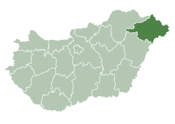
Szabolcs-Szatmár-Bereg (Hungarian pronunciation: [ˈsɒbolt͡ʃ ˈsɒtmaːr ˈbɛrɛɡ]) is an administrative county (Hungarian: megye) in north-eastern Hungary, bordering Slovakia, Ukraine, and Romania. It shares borders with the Hungarian counties Hajdú-Bihar and Borsod-Abaúj-Zemplén. The capital of Szabolcs-Szatmár-Bereg county is Nyíregyháza.
Szabolcs-Szatmár-Bereg county was organised after World War II from the previous counties Szatmár-Ugocsa-Bereg and Szabolcs. Before 1991, it was called Szabolcs-Szatmár county.
Many settlements founded after the conquest of the Magyars were largely devastated by the Mongol invasion in 1241. Recovery then took decades. The history of Nyíregyháza provides an illuminating example of this process. The Turks hardly succeeded in invading the northern parts of the region: therefore, many buildings from Árpád's age and the Medieval Era were preserved in relatively good state. In the Romanesque church of Csaroda, there are wall paintings dating back to the 13th century, and the Medieval churches of Nyírbátor have been almost completely preserved. In the 16th century, the spread of Protestantism and Calvinism brought about changes in town life.
...
Wikipedia


