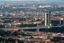
Nusle Bridge
| Nusle Bridge | |
|---|---|

Nusle Bridge with Corinthia Towers hotel
|
|
| Coordinates | 50°03′57″N 14°25′50″E / 50.065844°N 14.430483°ECoordinates: 50°03′57″N 14°25′50″E / 50.065844°N 14.430483°E |
| Carries | 6 lanes of roadway, 2 tracks of Prague Metro Line C, pedestrians |
| Crosses | Nusle Valley |
| Locale | Prague |
| Official name | Nuselský most |
| Characteristics | |
| Design | prestressed concrete hollow box haunched cantilever bridge |
| Total length | 485 metres (1,591 ft) |
| Width | 26.5 metres (87 ft) |
| Longest span | 115.5 metres (379 ft) |
| Clearance below | 42.5 metres (139 ft) |
| History | |
| Construction start | 1967 |
| Opened | 22 February 1973 |
Nusle Bridge (Czech: Nuselský most) is a prestressed concrete viaduct in Prague, passing over the district of Nusle in Prague 2 and Prague 4. It spans the Nusle Valley and connects the Pankrác district and south-eastern parts of the city, as well as the D1 motorway with the central part of the city. Below the six-lane highway on the surface, the section of Prague Metro Line C between I.P. Pavlova and Vyšehrad stations runs inside the bridge. Construction began in 1967, and it opened on 22 February 1973.
The bridge is crucial to Prague's transportation network, since almost all north-south traffic flows across its span. The bridge also has a darker side, garnering the nickname "Suicide bridge" due to the number of suicides and attempted suicides since its completion. To prevent further suicides, the city erected tall chain link fence railings along the sidewalks in 1997. In 2007, the fencing was topped off with a 3-foot-wide strip (0.91 m) of polished metal to make it impossible to climb.
View from the north
View from the south
View from the west (from Vyšehrad)
View from below
...
Wikipedia
