Nuris
| Nuris | |
|---|---|

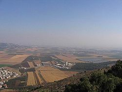
The Jezreel Valley today
|
|
| Arabic | نورِِِس |
| Also spelled | Noori |
| Subdistrict | Jenin |
| Coordinates | 32°32′06.4″N 35°21′48.9″E / 32.535111°N 35.363583°ECoordinates: 32°32′06.4″N 35°21′48.9″E / 32.535111°N 35.363583°E |
| Palestine grid | 184/215 |
| Population | 570 (1945) |
| Area | 6256 dunams |
| Date of depopulation | May 29–30, 1948 |
| Cause(s) of depopulation | Military assault by Yishuv forces |
| Secondary cause | Fear of being caught up in the fighting |
| Current localities | Nurit |
Nuris (Arabic: نورِِِس) was a Palestinian Arab village in the District of Jenin. In 1945, Nuris had 570 inhabitants. It was depopulated during the 1948 War on May 29, 1948 under Operation Gideon.
Nuris was located 9 kilometers (5.6 mi) northeast of Jenin, built on both sides of a shallow wadi. The Haifa-Beisan-Samakh railway-line passed northeast of the village. It was linked by dirt roads to the villages of Zir'in and Al-Mazar.
There were several springs north of Nuris, most importantly 'Ayn Jalut (or Jalud), "Spring of Goliath", which was one of the largest springs in Palestine.
Nuris was located in the Jezreel Valley and was referred to by the Crusaders as "Nurith." Nearby, the Mamluks decisively defeated the Mongols in the Battle of Ain Jalut in 1260.
In 1517, the village was included in the Ottoman Empire with the rest of Palestine, and in the 1596 tax-records it appeared part of the nahiya (subdistrict) of Jenin under the liwa' (district) of Lajjun, with a population of 88. It paid taxes on a number of products, including wheat, barley, olives, and goats and beehives.
...
Wikipedia

