Nowy Dwór Gdański
| Nowy Dwór Gdański | |||
|---|---|---|---|

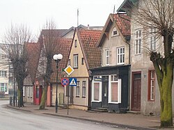
Ulica Sikorskiego, Nowy Dwór Gdański
|
|||
|
|||
| Coordinates: 54°13′N 19°7′E / 54.217°N 19.117°E | |||
| Country |
|
||
| Voivodeship | Pomeranian | ||
| County | Nowy Dwór Gdański County | ||
| Gmina | Gmina Nowy Dwór Gdański | ||
| Area | |||
| • Total | 5.06 km2 (1.95 sq mi) | ||
| Population (2012) | |||
| • Total | 10,171 | ||
| • Density | 2,000/km2 (5,200/sq mi) | ||
| Postal code | 82-100 | ||
| Climate | Cfb | ||
| Website | http://www.miastonowydwor.pl/ | ||
Nowy Dwór Gdański [ˈnɔvɨ ˈdvur ˈɡdaɲskʲi] (German: Tiegenhof) is a town in Poland on the Tuja river in the Żuławy Wiślane region, capital of Nowy Dwór Gdański County, located in Pomeranian Voivodeship, with 10,171 inhabitants (2012).
Before 1772 the area was part of Kingdom of Poland, 1772-1919 Prussia and Germany, 1920-1939 Free City of Danzig, September 1939 - February 1945 Nazi Germany. For the history of the region, see History of Pomerania.
Nowy Dwór Gdański is twinned with:
Coordinates: 54°13′N 19°07′E / 54.217°N 19.117°E
...
Wikipedia


