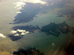
Notojima
| Native name: 能登島 Notojima | |
|---|---|
 |
|
|
Location in Japan
|
|
| Geography | |
| Location | Sea of Japan |
| Coordinates | 37°07′30″N 136°59′47″E / 37.12500°N 136.99639°ECoordinates: 37°07′30″N 136°59′47″E / 37.12500°N 136.99639°E |
| Area | 46.78 km2 (18.06 sq mi) |
| Length | 11 km (6.8 mi) |
| Width | 2 km (1.2 mi) |
| Coastline | 71.9 km (44.68 mi) |
| Highest elevation | 196.8 m (645.7 ft) |
| Highest point | mount Yomurazuka |
| Administration | |
|
Japan
|
|
| Prefecture | Ishikawa Prefecture |
| City | Nanao |
| Demographics | |
| Population | 3187 (2003) |
| Pop. density | 68.13 /km2 (176.46 /sq mi) |
| Ethnic groups | Japanese |
Notojima (能登島 Noto-jima?) is a volcanic island in the Nanao Bay (七尾湾) portion of the Sea of Japan, less than 500 meters off the coast of the Ishikawa prefecture in Japan. Notojima Island is administered as part of Nanao city. The two bridges connecting Notojima to the mainland trisect into Nanao-North, Nanao-West and Nanao-Nambu bays. The island's highest peak is Mount Yomurazuka 196.8 m (646 ft). The island has both elementary and middle schools.
...
Wikipedia


