Norwich, Massachusetts
| Huntington, Massachusetts | ||
|---|---|---|
| Town | ||

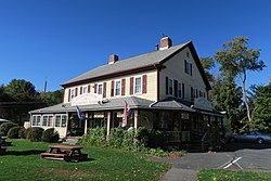
Huntington Country Store
|
||
|
||
 Location in Hampshire County in Massachusetts |
||
| Coordinates: 42°14′10″N 72°52′35″W / 42.23611°N 72.87639°WCoordinates: 42°14′10″N 72°52′35″W / 42.23611°N 72.87639°W | ||
| Country | United States | |
| State | Massachusetts | |
| County | Hampshire | |
| Settled | 1769 | |
| Incorporated | 1775 | |
| Government | ||
| • Type | Open town meeting | |
| Area | ||
| • Total | 26.8 sq mi (69.4 km2) | |
| • Land | 26.3 sq mi (68.2 km2) | |
| • Water | 0.5 sq mi (1.2 km2) | |
| Elevation | 382 ft (116 m) | |
| Population (2010) | ||
| • Total | 2,180 | |
| • Density | 83/sq mi (32.0/km2) | |
| Time zone | Eastern (UTC-5) | |
| • Summer (DST) | Eastern (UTC-4) | |
| ZIP Code | 01050 | |
| Area code(s) | 413 | |
| FIPS code | 25-31785 | |
| GNIS feature ID | 0618203 | |
| Website | www |
|
Huntington is a town in Hampshire County, Massachusetts, United States. The population was 2,180 at the 2010 census. It is part of the Springfield, Massachusetts Metropolitan Statistical Area.
Originally Plantation Number 9 by the Court of Massachusetts Bay, Huntington has a colorful history, hinted at by the town's incorporation date of March 5, 1855, decades later than the towns around it. The town was assembled from pieces of surrounding towns, which were grafted onto the towns of Norwich, Murrayfield, and Knightville. The present village center sits on what was the meeting point of three towns and two counties. The location of the village created a tangle of jurisdictional confusion. With the coming of the railroad in the 1840s and the expansion of industry and population that came with it, the political difficulties that the boundaries presented became untenable.
The solution that resulted in the present town was crafted by a Northampton attorney named Charles Huntington. Once the new town was incorporated, Mr. Huntington presented it with a gift that was the foundation of the town's library. After some discussion, the newly formed town voted to adopt the name of "Huntington", in honor of its recent architect and benefactor.
Huntington is in southwestern Hampshire County, bordered to the south and west by towns in Hampden County. The Westfield River runs through the town, joined by its West Branch at the village of Huntington in the southern part of the town. U.S. Route 20 follows the lower Westfield River and its West Branch through the town, leading southeast 12 miles (19 km) to the city of Westfield and northwest 23 miles (37 km) to Lee.
According to the United States Census Bureau, the town of Huntington has a total area of 26.8 square miles (69.4 km2), of which 26.3 square miles (68.2 km2) are land and 0.46 square miles (1.2 km2), or 1.78%, are water.
...
Wikipedia

