Norwalk, OH
| Norwalk, Ohio | ||
|---|---|---|
| City | ||

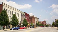
Uptown Norwalk, looking east on West Main Street
|
||
|
||
| Nickname(s): The Maple City | ||
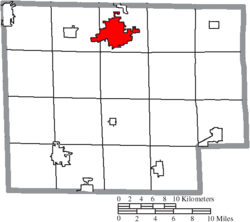
 Location of Norwalk, Ohio |
||
 Location of Norwalk in Huron County |
||
| Coordinates: 41°14′35″N 82°36′41″W / 41.24306°N 82.61139°WCoordinates: 41°14′35″N 82°36′41″W / 41.24306°N 82.61139°W | ||
| Country | United States | |
| State | Ohio | |
| County | Huron | |
| Founded | 1817 | |
| Government | ||
| • Mayor | Rob Duncan | |
| Area | ||
| • Total | 9.15 sq mi (23.70 km2) | |
| • Land | 8.87 sq mi (22.97 km2) | |
| • Water | 0.28 sq mi (0.73 km2) | |
| Elevation | 719 ft (219 m) | |
| Population (2010) | ||
| • Total | 17,012 | |
| • Estimate (2012) | 16,931 | |
| • Density | 1,917.9/sq mi (740.5/km2) | |
| Time zone | Eastern (EST) (UTC-5) | |
| • Summer (DST) | EDT (UTC-4) | |
| ZIP code | 44857 | |
| Area code(s) | 419, 567 | |
| FIPS code | 39-57302 | |
| GNIS feature ID | 1044003 | |
| Website | http://www.norwalkoh.com/ | |
Norwalk is a city in and the county seat of Huron County, Ohio, United States. The population was 17,012 at the 2010 census. The city is the center of the Norwalk Micropolitan Statistical Area and part of the Cleveland-Akron-Canton Combined Statistical Area. Norwalk is located approximately 10 miles (16 km) south of Lake Erie, 51 miles (82 km) west/southwest of Cleveland, 59 miles (95 km) southeast of Toledo, and 87 miles (140 km) north/northeast of Columbus.
Norwalk is at the center of the Firelands, a subregion of the Connecticut Western Reserve. The subregion's name recalls the founding of the area as one for settlers from cities in Connecticut that were burned during the Revolutionary War. Several locations in the Firelands were named in honor of those cities, including Danbury, Greenwich, Groton, New Haven, New London, Norwalk, Norwich, and Ridgefield. Other locations were named for the settlers, including Clarksfield, Perkins, and Sherman.
...
Wikipedia

