North Solomons Province
| Autonomous Region of Bougainville |
|||
|---|---|---|---|
|
|||
 Bougainville Province in Papua New Guinea |
|||
| Coordinates: 6°0′S 155°0′E / 6.000°S 155.000°E | |||
| Country |
|
||
| Capital | Buka (interim) | ||
| Districts | |||
| Government | |||
| • President | John Momis (2010–present) | ||
| • Vice-President | Raymond Masono (2017–present) | ||
| Area | |||
| • Total | 9,384 km2 (3,623 sq mi) | ||
| Population (2011 census) | |||
| • Total | 249,358 | ||
| • Density | 27/km2 (69/sq mi) | ||
| Time zone | Bougainville Standard Time (UTC+11) | ||
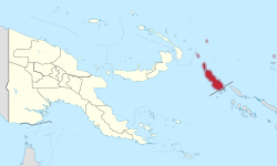
The Autonomous Region of Bougainville (/ˌboʊɡənˈvɪl/ BOE-gən-VIL), previously known as the North Solomons Province, is an autonomous region in Papua New Guinea. The largest island is Bougainville Island (also the largest of the Solomon Islands archipelago). The province also includes Buka Island and assorted outlying nearby islands including the Carterets. The capital is temporarily Buka, though it is expected that Arawa will be the permanent provincial capital. The population of the province is 249,358 (2011 census).
Bougainville Island is ecologically and geographically part of the Solomon Islands archipelago but is not politically part of the nation of Solomon Islands. Buka, Bougainville, and most of the Solomons are part of the Solomon Islands rain forests ecoregion.
The island was named after the French explorer Louis Antoine de Bougainville, who made expeditions to the Pacific. He is also the namesake of the tropical flowering vines of the genus Bougainvillea. In 1885, the island was taken over by a German administration as part of German New Guinea. Australia occupied it in 1914 during World War I. After the war the League of Nations designated it as a mandatory power and administered the island from 1918 until the Japanese invaded it in 1942 during World War II.
...
Wikipedia

