North Kansas City, Missouri
| North Kansas City, Missouri | |
|---|---|
| City | |
| Nickname(s): Northtown, NKC | |
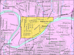
 Location of North Kansas City, Missouri |
|
 U.S. Census map |
|
| Coordinates: 39°8′20″N 94°34′14″W / 39.13889°N 94.57056°WCoordinates: 39°8′20″N 94°34′14″W / 39.13889°N 94.57056°W | |
| Country | United States |
| State | Missouri |
| County | Clay |
| Area | |
| • Total | 4.63 sq mi (11.99 km2) |
| • Land | 4.39 sq mi (11.37 km2) |
| • Water | 0.24 sq mi (0.62 km2) |
| Elevation | 741 ft (226 m) |
| Population (2010) | |
| • Total | 4,208 |
| • Estimate (2012) | 4,287 |
| • Density | 958.5/sq mi (370.1/km2) |
| Time zone | Central (CST) (UTC-6) |
| • Summer (DST) | CDT (UTC-5) |
| ZIP code | 64116 |
| Area code(s) | 816 |
| FIPS code | 29-53102 |
| GNIS feature ID | 0723477 |
| Website | City of North Kansas City |
North Kansas City is a city in Clay County, Missouri, United States and is an independent municipality that is a part of the Kansas City metropolitan area. The population was 4,208 at the 2010 census. Originally a northern suburb across the Missouri River from Kansas City, Missouri, it is now almost completely surrounded by Kansas City, which has annexed far to the north of North Kansas City's northern city limits. North Kansas City also adjoins the small municipality of Avondale.
North Kansas City is located at 39°8′20″N 94°34′14″W / 39.13889°N 94.57056°W (39.139007, -94.570518).
According to the United States Census Bureau, the city has a total area of 4.63 square miles (11.99 km2), of which, 4.39 square miles (11.37 km2) is land and 0.24 square miles (0.62 km2) is water.
Highways connecting North Kansas City with the surrounding area are Interstate 29/35/US 71, Missouri Route 1 (Vernon Street), Route 9 (Burlington Street), Route 210 (Armour Road), Route 269 (Chouteau Trafficway), and Route 283 (North Oak Trafficway). The US 169 (Broadway Extension) freeway runs immediately to the west of North Kansas City's city limits.
...
Wikipedia
