North Fork Skokomish River
| Skokomish River | |
|---|---|

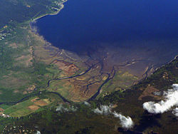
Skokomish River Delta on Hood Canal
|
|
| Country | United States |
| Physical characteristics | |
| Main source | Mount Skokomish, Olympic Mountains (North Fork); Sundown Pass, Olympic Mountains (South Fork) |
| River mouth |
Hood Canal sea level |
| Length | 69 km (43 mi) |
| Discharge |
|
| Basin features | |
| Basin size | 588 km2 (227 sq mi) |
The Skokomish River is a river in Mason County, Washington, United States. It is the largest river flowing into Hood Canal, an arm of Puget Sound. From its source at the confluence of the North and South Forks the main stem Skokomish River is approximately 9 miles (14 km) long. The longer South Fork Skokomish River is 40 miles (64 km), making the length of the whole river via its longest tributary about 49 miles (79 km). The North Fork Skokomish River is approximately 34 miles (55 km) long. A significant part of the Skokomish River's watershed is within Olympic National Forest and Olympic National Park.
The Skokomish River and its two tributary forks drain the southeast corner of the Olympic Mountains, mainly in Mason County but including a portion of Jefferson County. The main stem Skokomish River is formed by the confluence of the North Fork and South Fork near small community of Mohrweis. It flows east through the broad Skokomish Valley. After being crossed by U.S. Route 101 the river turns northeast. Washington State Route 106 crosses the river near its mouth on Hood Canal. Near the towns of Union and Skokomish the Skokomish River enters Annas Bay at The Great Bend of Hood Canal from the south, where it creates a large estuary called Skokomish Flats. The lower portion of the river flows through the Skokomish Indian Reservation.
The South Fork Skokomish River originates near Sundown Pass in Olympic National Park, near the sources of the Wynoochee River and Graves Creek, a tributary of the Quinault River. The South Fork flows southeast out of the national park and between Capitol Peak, on the west, and Wonder Mountain on the east. After receiving Rule Creek from the west the South Fork turns more directly south and enters a broader valley. It receives Church Creek from the west, then turns to flow southeast and east through a widening river valley. A number of tributary streams join the South Fork, including Pine Creek and Cedar Creek, from the south, and Le Bar Creek, Brown Creek, and Harp Creek from the north. The South Fork Skokomish leaves the main Olympic Mountains and enters flatter terrain, but flows through gorges for several miles. After exiting the gorges the South Fork turns east and enters the broad Skokomish Valley where it joins with the North Fork to form the main stem Skokomish River.
...
Wikipedia
