North Eastham
| North Eastham, Massachusetts | |
|---|---|
| Census-designated place | |
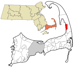
 Location in Barnstable County and the state of Massachusetts. |
|
| Coordinates: 41°51′5″N 70°00′00″W / 41.85139°N 70.00000°W | |
| Country | United States |
| State | Massachusetts |
| County | Barnstable |
| Town | Eastham |
| Area | |
| • Total | 11.9 sq mi (30.9 km2) |
| • Land | 3.4 sq mi (8.9 km2) |
| • Water | 8.5 sq mi (22.0 km2) |
| Elevation | 39 ft (12 m) |
| Population (2010) | |
| • Total | 1,806 |
| • Density | 526/sq mi (203.0/km2) |
| Time zone | Eastern (EST) (UTC-5) |
| • Summer (DST) | EDT (UTC-4) |
| ZIP code | 02651 |
| Area code(s) | 508 |
| FIPS code | 25-47590 |
| GNIS feature ID | 0616892 |
North Eastham is a census-designated place (CDP) in the town of Eastham in Barnstable County, Massachusetts, United States. The population was 1,806 at the 2010 census.
The main visitor center of the Cape Cod National Seashore is located in North Eastham.
North Eastham is located within the northwestern part of the Town of Eastham at 41°51′05″N 70°00′00″W / 41.851349°N 69.999928°WCoordinates: 41°51′05″N 70°00′00″W / 41.851349°N 69.999928°W (41.851349, -69.999928). It is bordered to the west by Cape Cod Bay, to the north by the town of Wellfleet, to the east by U.S. Route 6 and Great Pond Road, and to the south by Great Pond, Herring Brook Road, and Samoset Road.
...
Wikipedia
