North Derbyshire
| Derbyshire | |||||
|---|---|---|---|---|---|
| County | |||||
|
|||||
| Motto: "Bene consulendo" ("By wise deliberation") | |||||
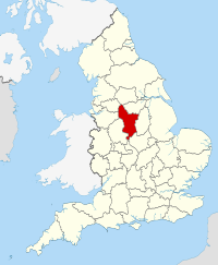
 Derbyshire in England |
|||||
| Coordinates: 53°8′N 1°36′W / 53.133°N 1.600°WCoordinates: 53°8′N 1°36′W / 53.133°N 1.600°W | |||||
| Sovereign state | United Kingdom | ||||
| Country | England | ||||
| Region | East Midlands | ||||
| Established | Ancient | ||||
| Ceremonial county | |||||
| Lord Lieutenant | William Tucker | ||||
| High Sheriff | Elizabeth Fothergill (2016–17) | ||||
| Area | 2,625 km2 (1,014 sq mi) | ||||
| • Ranked | 21st of 48 | ||||
| Population (mid-2015 est.) | 1,036,600 | ||||
| • Ranked | 20th of 48 | ||||
| Density | 394/km2 (1,020/sq mi) | ||||
| Ethnicity | 96.0% White 2.3% S. Asian 1.7% Black, Mixed Race or Chinese |
||||
| Non-metropolitan county | |||||
| County council | Derbyshire County Council | ||||
| Executive | Conservative | ||||
| Admin HQ | Matlock | ||||
| Area | 2,547 km2 (983 sq mi) | ||||
| • Ranked | 20th of 27 | ||||
| Population | 782,400 | ||||
| • Ranked | 11th of 27 | ||||
| Density | 307/km2 (800/sq mi) | ||||
| ISO 3166-2 | GB-DBY | ||||
| ONS code | 17 | ||||
| GSS code | E10000007 | ||||
| NUTS | UKF12, UKF13 | ||||
| Website | www |
||||
 Districts of Derbyshire Unitary County council area |
|||||
| Districts | |||||
| Members of Parliament | List of MPs | ||||
| Police | Derbyshire Constabulary | ||||
| Time zone | GMT (UTC) | ||||
| • Summer (DST) | BST (UTC+1) | ||||
Derbyshire (![]() i/ˈdɑːrbᵻʃər/ or /ˈdɑːrbɪʃɪər/; abbreviated Derbys. or Derbs.) is a county in the East Midlands of England. A substantial portion of the Peak District National Park lies within Derbyshire, containing the southern extremity of the Pennine range of hills which extend into the north of the county. The county contains part of the National Forest, and borders on Greater Manchester to the northwest, West Yorkshire to the north, South Yorkshire to the northeast, Nottinghamshire to the east, Leicestershire to the southeast, Staffordshire to the west and southwest and Cheshire also to the west. Kinder Scout, at 636 metres (2,087 ft), is the highest point in the county, whilst Trent Meadows, where the River Trent leaves Derbyshire, is its lowest point at 27 metres (89 ft). The River Derwent is the county's longest river at 66 miles (106 km), and runs roughly north to south through the county. In 2003 the Ordnance Survey placed Church Flatts Farm at Coton in the Elms (near Swadlincote) as the furthest point from the sea in Great Britain.
i/ˈdɑːrbᵻʃər/ or /ˈdɑːrbɪʃɪər/; abbreviated Derbys. or Derbs.) is a county in the East Midlands of England. A substantial portion of the Peak District National Park lies within Derbyshire, containing the southern extremity of the Pennine range of hills which extend into the north of the county. The county contains part of the National Forest, and borders on Greater Manchester to the northwest, West Yorkshire to the north, South Yorkshire to the northeast, Nottinghamshire to the east, Leicestershire to the southeast, Staffordshire to the west and southwest and Cheshire also to the west. Kinder Scout, at 636 metres (2,087 ft), is the highest point in the county, whilst Trent Meadows, where the River Trent leaves Derbyshire, is its lowest point at 27 metres (89 ft). The River Derwent is the county's longest river at 66 miles (106 km), and runs roughly north to south through the county. In 2003 the Ordnance Survey placed Church Flatts Farm at Coton in the Elms (near Swadlincote) as the furthest point from the sea in Great Britain.
...
Wikipedia


