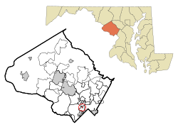
North Chevy Chase, Maryland
| North Chevy Chase, Maryland | |
|---|---|
| Village | |
 Location of North Chevy Chase, Maryland |
|
| Coordinates: 39°0′6″N 77°4′26″W / 39.00167°N 77.07389°WCoordinates: 39°0′6″N 77°4′26″W / 39.00167°N 77.07389°W | |
| Country | |
| State |
|
| County |
|
| Area | |
| • Total | 0.11 sq mi (0.28 km2) |
| • Land | 0.11 sq mi (0.28 km2) |
| • Water | 0 sq mi (0 km2) |
| Elevation | 276 ft (84 m) |
| Population (2010) | |
| • Total | 519 |
| • Estimate (2012) | 575 |
| • Density | 4,718.2/sq mi (1,821.7/km2) |
| Time zone | Eastern (EST) (UTC-5) |
| • Summer (DST) | EDT (UTC-4) |
| FIPS code | 24-56400 |
| GNIS feature ID | 0590889 |
North Chevy Chase is a village in Montgomery County, Maryland, United States. It was established as a Special Tax District in 1924 and incorporated as a village in 1996. The population was 519 at the 2010 census.
North Chevy Chase is located at 39°0′6″N 77°4′26″W / 39.00167°N 77.07389°W (39.001709, -77.073908).
According to the United States Census Bureau, the village has a total area of 0.11 square miles (0.28 km2), all of it land.
It lies immediately south of the Capital Beltway (I-495) just to the east of the interchange with Connecticut Avenue (MD 185). The village is bisected by Kensington Parkway which runs parallel to Connecticut Avenue.
North Chevy Chase lies on the site of Clean Drinking plantation, a much larger colonial land grant visited by George Washington as reported in his diary. Residential development of the area began in the early 20th century when William H. Walker laid out a community and began selling lots. In 1924, residents incorporated as a special tax district but it was not fully incorporated as a municipality until 1996.
As of the census of 2010, there were 519 people, 189 households, and 144 families residing in the village. The population density was 4,718.2 inhabitants per square mile (1,821.7/km2). There were 195 housing units at an average density of 1,772.7 per square mile (684.4/km2). The racial makeup of the village was 83.8% White, 7.7% African American, 5.4% Asian, 0.8% from other races, and 2.3% from two or more races. Hispanic or Latino of any race were 4.6% of the population.
...
Wikipedia
