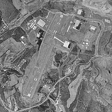
North Central West Virginia Airport
| North Central West Virginia Airport | |||||||||||
|---|---|---|---|---|---|---|---|---|---|---|---|
 |
|||||||||||

USGS 1997 orthophoto
|
|||||||||||
| Summary | |||||||||||
| Airport type | Public | ||||||||||
| Owner | Benedum Airport Authority | ||||||||||
| Serves | Clarksburg / Fairmont, West Virginia | ||||||||||
| Location | Bridgeport, West Virginia | ||||||||||
| Elevation AMSL | 1,224 ft / 373 m | ||||||||||
| Coordinates | 39°17′48″N 080°13′41″W / 39.29667°N 80.22806°WCoordinates: 39°17′48″N 080°13′41″W / 39.29667°N 80.22806°W | ||||||||||
| Website | FlyCKB.com | ||||||||||
| Map | |||||||||||
| Location of airport in West Virginia / United States | |||||||||||
| Runways | |||||||||||
|
|||||||||||
| Helipads | |||||||||||
|
|||||||||||
| Statistics (2011) | |||||||||||
|
|||||||||||
|
Source: FAA and airport website
|
|||||||||||
| Aircraft operations | 24,600 |
|---|---|
| Based aircraft | 80 |
North Central West Virginia Airport (IATA: CKB, ICAO: KCKB, FAA LID: CKB) is a joint-use public and military airport located one nautical mile (2 km) northeast of the central business district of Bridgeport, a city in Harrison County, West Virginia, United States. While located in Bridgeport, the airport is primarily associated with Clarksburg, West Virginia. It is owned and operated by the Benedum Airport Authority, serving Harrison and Marion County, and was formerly known as Benedum Airport and Harrison-Marion Regional Airport. The airport is served by one commercial airline with scheduled passenger service subsidized by the Essential Air Service program.
As per Federal Aviation Administration records, the airport had 10,344 passenger boardings (enplanements) in calendar year 2008, 10,234 enplanements in 2009, and 10,694 in 2010. It is included in the National Plan of Integrated Airport Systems for 2011–2015, which categorized it as a primary commercial service airport (more than 10,000 enplanements per year).
The airport first opened in 1935 as the Tri-County Airport, a joint effort of Harrison, Marion and Taylor County. It was a grass airstrip operated on leased land. In 1937, Marion and Taylor County withdrew from the project. In 1938, Harrison County purchased additional land and expanded the airport. The current airport authority was established in 1960. The runway was extended to a length of 7,000 feet (2,100 m) in 1999.
...
Wikipedia


