North Canton, OH
| North Canton, Ohio | |
|---|---|
| City | |

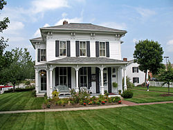
House at the Hoover Farm
|
|
| Nickname(s): The Dogwood City | |
 Location of North Canton, Ohio |
|
 Location of North Canton in Stark County |
|
| Coordinates: 40°52′30″N 81°24′4″W / 40.87500°N 81.40111°WCoordinates: 40°52′30″N 81°24′4″W / 40.87500°N 81.40111°W | |
| Country | United States |
| State | Ohio |
| County | Stark |
| Government | |
| • Mayor | David J. Held |
| Area | |
| • Total | 6.40 sq mi (16.58 km2) |
| • Land | 6.40 sq mi (16.58 km2) |
| • Water | 0 sq mi (0 km2) |
| Elevation | 1,161 ft (354 m) |
| Population (2010) | |
| • Total | 17,488 |
| • Estimate (2012) | 17,404 |
| • Density | 2,732.5/sq mi (1,055.0/km2) |
| Time zone | Eastern (EST) (UTC-5) |
| • Summer (DST) | EDT (UTC-4) |
| ZIP codes | 44709, 44720, 44799 |
| Area code(s) | 330 |
| FIPS code | 39-56294 |
| GNIS feature ID | 1065163 |
| Website | http://www.northcantonohio.com/ |
North Canton is a city in Stark County in the U.S. state of Ohio. The population was 17,488 at the 2010 United States Census. It is part of the Canton-Massillon, OH Metropolitan Statistical Area.
In 1831, the Community of North Canton first began as the Village of New Berlin. Residents were primarily of German descent. William H. “Boss” Hoover moved his tannery business from the family farm to the center of the North Canton village in 1873. In 1908, The Hoover Company began manufacturing vacuum cleaners. During World War I, in 1918, the community changed the name of the village to North Canton. The Hoover Company became the world’s largest manufacturer of vacuum cleaners in 1933. The North Canton Jaycees were formed in 1951. In 2007, the Hoover Company officially shut down. The Hoover Company's old building was bought in 2010 for residential, educational, and recreational proposes. The old Hoover Company building was sold by sections in 2013 to be transformed into a mall and apartments.
North Canton is located at 40°52′30″N 81°24′4″W / 40.87500°N 81.40111°W (40.875007, -81.401053). The West Branch of Nimishillen Creek flows through the city.
According to the United States Census Bureau, the city has a total area of 6.40 square miles (16.58 km2), all land.
As of the census of 2010, there were 17,488 people, 7,557 households, and 4,426 families residing in the city. The population density was 2,732.5 inhabitants per square mile (1,055.0/km2). There were 8,078 housing units at an average density of 1,262.2 per square mile (487.3/km2). The racial makeup of the city was 94.8% White, 2.0% African American, 0.2% Native American, 1.1% Asian, 0.3% from other races, and 1.5% from two or more races. Hispanic or Latino of any race were 1.5% of the population.
...
Wikipedia
