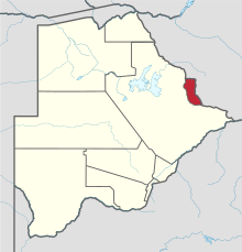
North-East District (Botswana)
| North-East | |
|---|---|
| District | |

Shashe River centre
|
|
 Location within Botswana |
|
| Coordinates: 21°5′S 27°30′E / 21.083°S 27.500°ECoordinates: 21°5′S 27°30′E / 21.083°S 27.500°E | |
| Country |
|
| Capital | Francistown |
| Area | |
| • Total | 5,120 km2 (1,980 sq mi) |
| Population (2013 census) | |
| • Total | 167,500 |
| • Density | 33/km2 (85/sq mi) |
| Time zone | Central Africa Time (UTC+2) |
The North-East District is one of the administrative districts of Botswana. Its capital is Francistown. In 2013, North-East had a population of 167,500 people. The North-East District is predominantly occupied by Kalanga speaking people (the BaKalanga).
In the north and east, North-East borders the Matabeleland South Province of Zimbabwe with the border in the east predominantly the Ramokgwebana River Center. In the south and west, North-East District borders Central District and the border being the Shashe River Center.
The district is administered by a district administration and district council which are responsible for local administration. As of 2011, the total population of the district was 60,264 compared to 49,399 in 2001. The growth rate of population during the decade was 2.01. The total number of workers constituted 14,633 with 7,134 males and 7,498 females.
Most part of Botswana has tableland slopes sliding from east to west. The region has an average elevation of around 915 m (3,002 ft) above the mean sea level. The vegetation type is Savannah, with tall grasses, bushes and tress. The annual precipitation is around 65 cm (26 in), most of which is received during the summer season from November to May. Most of the rivers in the region are seasonal, with Limpopo River, which are prone to flash floods, being the most prominent. There are conflicts between agricultural expansion and protection of indigenous wildlife within the Central District. There are several seasonal rivers in the district which flows in the rainy season reach the Makgadikgadi Pans.
The Nata River flows through the North-East District and is a significant gathering place for wildlife including birds. The Nata River continues to flow to the Makgadikgadi Pans, where it discharges.
...
Wikipedia
