Norridgewock
|
Norridgewock Archeological District
|
|

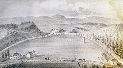
Old Point in 1849
|
|
| Location | Norridgewock, Starks, and Madison, Maine |
|---|---|
| Coordinates | 44°46′1″N 69°53′0″W / 44.76694°N 69.88333°W |
| Built | 1625 |
| NRHP Reference # | |
| Significant dates | |
| Added to NRHP | April 12, 1993 |
| Designated NHLD | April 12, 1993 |
Norridgewock was the name of both an Indian village and a band of the Abenaki ("People of the Dawn") Native Americans/First Nations, an Eastern Algonquian tribe of the United States and Canada. The French of New France called the village Kennebec. The tribe occupied an area in the interior of Maine. During colonial times, this area was territory disputed between British and French colonists, and was set along the claimed western border of Acadia, the western bank of the Kennebec River.
Archaeological evidence has identified several different sites associated with the settlement known as Norridgewock. The last one, where the French Jesuit priest Sebastian Rale had a mission, is today called Old Point, and is located in Madison. Other sites are located nearby in Starks and the present-day town of Norridgewock. Three of these historically and archaeologically significant areas have been collectively designated as the Norridgewock Archaeological District, a National Historic Landmark District.
Norridgewock is a corruption of the word Nanrantsouak, meaning "people of the still water between the rapids". Their principal village, also called Norridgewock, was located near 44°46′01″N 69°53′00″W / 44.767°N 69.8833°WCoordinates: 44°46′01″N 69°53′00″W / 44.767°N 69.8833°W on a plateau within a broad bend of the Kennebec River, opposite its confluence with the Sandy River. A 1716 account by soldier/surveyor Joseph Heath describes the village as a square fort surrounded by a 9-foot (2.7 m) palisade fence, each side 160 feet (49 m) long with a gate at its center. The fort's walls faced the major points of the compass. Two streets connected the gates, forming an open square at the center marked by a large cross. The stockade enclosed 26 cabins "built much after the English manner"—probably of logs. Canoes were beached along the river, although paddles were stored in the cabins. Extensive fields were cleared nearby for cultivation of maize, wheat, beans, pumpkins and squash. Twice a year, summer and winter, the tribe spent a few months at the seashore catching fish, seals, clams, oysters and seafowl.
...
Wikipedia


