Nordre Aker
| Bydel Nordre Aker | ||
|---|---|---|
| District | ||
 |
||
|
||
 |
||
| Country | Norway | |
| City | Oslo | |
| Area | ||
| • Total | 13.57 km2 (5.24 sq mi) | |
| Population (2004) | ||
| • Total | 41,452 | |
| • Density | 3,100/km2 (7,900/sq mi) | |
| Time zone | CET (UTC+1) | |
| • Summer (DST) | CEST (UTC+2) | |
| ISO 3166 code | NO-030108 | |
| Website | bydel-nordre-aker.oslo.kommune.no | |
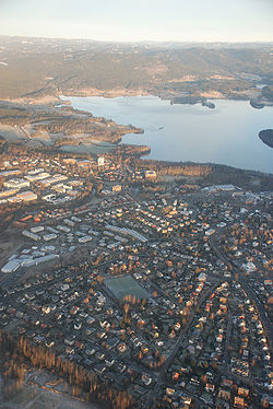
Nordre Aker is a district of the city of Oslo, Norway.
This area became part of the city of Oslo in 1948. Before that it was a part of Aker municipality in Akershus county.
With a population of 43,843 Nordre Aker ranks fifth among the boroughs.
Detached housing dominates the western part of the district. There are also high-rise student blocks at several locations, including Vestgrensa, Sogn, Fjellbirkeland and Kringsjå.
The district is north of the city centre, and represents the last major settlement before the northern forested area starts. It is bordered by Marka in the north and east, Vestre Aker in the west, Frogner in the southwest, St. Hanshaugen, Sagene and a small part of Grünerløkka in the south and Bjerke in the east.
The district consists of several neighborhoods, from west to east: Gaustad, Øvre Blindern, Ullevål Hageby, Sogn, Kringsjå, Nordberg, Korsvoll, Tåsen, Ullevål, Berg, Nydalen, Storo, Frysja, Disen, Kjelsås, Grefsen and Nordre Åsen.
The major body of water in the borough is the river Akerselva. The western border of the borough is formed by a creek, Sognsvannsbekken. The lake Sognsvann is not located in Nordre Aker, albeit the parking lot and metro leading to it is.
...
Wikipedia

