Noord-Beveland
| Noord-Beveland (North Beveland) |
|||
|---|---|---|---|
| Municipality | |||

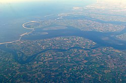
Aerial view of Noord-Beveland
|
|||
|
|||
 Location in Zeeland |
|||
| Coordinates: 51°35′N 3°45′E / 51.583°N 3.750°ECoordinates: 51°35′N 3°45′E / 51.583°N 3.750°E | |||
| Country | Netherlands | ||
| Province | Zeeland | ||
| Government | |||
| • Body | Municipal council | ||
| • Mayor | Marcel Delhez (VVD) | ||
| Area | |||
| • Total | 121.51 km2 (46.92 sq mi) | ||
| • Land | 85.82 km2 (33.14 sq mi) | ||
| • Water | 35.69 km2 (13.78 sq mi) | ||
| Elevation | 1 m (3 ft) | ||
| Population (May 2014) | |||
| • Total | 7,469 | ||
| • Density | 87/km2 (230/sq mi) | ||
| Demonym(s) | Noord-Bevelander | ||
| Time zone | CET (UTC+1) | ||
| • Summer (DST) | CEST (UTC+2) | ||
| Postcode | 4484–4499 | ||
| Area code | 0113 | ||
| Website | www |
||
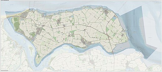
Noord-Beveland(Dutch pronunciation: [ˈnoːrd ˈbeːvəlɑnt]) (North Beveland) is a municipality and region in the southwestern Netherlands and a former island, now part of the Walcheren-Zuid-Beveland-Noord-Beveland peninsula. Noord-Beveland is enclosed by the Oosterschelde estuary to the north, and the former straits, now combined lake, of Veerse Meer and Zandkreek to the south. As part of the Delta Works, dams have connected Noord-Beveland to Walcheren and Zuid-Beveland.
(there is no village called Noord-Beveland itself).
Dutch Topographic map of the municipality of Noord-Beveland, June 2015
In Roman times, the town of Ganuenta lay north of where the village of Colijnsplaat is now, a location now covered by the water of the Oosterschelde. It was an important centre for trade. Nearby, there was a temple dedicated to the ancient regional sea goddess Nehalennia. A replica of this temple was officially opened in Colijnsplaat in August 2005.
...
Wikipedia


