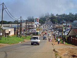
Nongoma
| Nongoma | |
|---|---|

Street in Nongoma
|
|
|
|
|
| Coordinates: 27°53′S 31°38′E / 27.883°S 31.633°ECoordinates: 27°53′S 31°38′E / 27.883°S 31.633°E | |
| Country | South Africa |
| Province | KwaZulu-Natal |
| District | Zululand |
| Municipality | Nongoma |
| Established | 1887 |
| Area | |
| • Total | 8.50 km2 (3.28 sq mi) |
| Elevation | 802 m (2,631 ft) |
| Population (2011) | |
| • Total | 7,629 |
| • Density | 900/km2 (2,300/sq mi) |
| Racial makeup (2011) | |
| • Black African | 97.0% |
| • Coloured | 0.8% |
| • Indian/Asian | 0.7% |
| • White | 0.9% |
| • Other | 0.6% |
| First languages (2011) | |
| • Zulu | 92.7% |
| • English | 2.3% |
| • S. Ndebele | 1.2% |
| • Other | 3.8% |
| PO box | 3950 |
| Area code | 035 |
Nongoma is a town in Zululand, KwaZulu-Natal, South Africa. It is the seat of the Nongoma Local Municipality. It is situated 300 km north of Durban and 56 km from Ulundi; it is surrounded by the Ngome Forest. It is a busy market town that serves a large surrounding area.
The area has five royal palaces belonging to the current Zulu King Goodwill Zwelithini:
This area was once the home of King Zwide, a late 18th-century Ndwandwe monarch who was eventually defeated by Shaka at the beginning of the Mfecane wars. On 30 March 1883, a Zulu regiment, the Mandlakazi under Zibhebhu, defeated the uSuthu (another Zulu regiment representing King Cetshwayo kaMpande) in the Msebe Valley near Nongoma.
The town itself was only established in 1887 with the building of Fort Ivuna by the British as a buffer zone between the Zulu warring factions. It was originally called Ndwandwe but was later replaced by an earlier name given by the local tribesmen to the sacred area where the town stands: KwaNongoma ("place of the diviner or mother of songs"). In June 1888 Nongoma was destroyed by the uSuthu but later rebuilt. The fort was used during the Bambatha Rebellion of 1906.
Two Zulu monarchs are laid to rest in the Nongoma area:
...
Wikipedia


