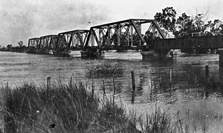
Nogoa River
| Nogoa | |
| River | |
|
Railway bridge in Emerald during a flood, 1918
|
|
| Country | Australia |
|---|---|
| State | Queensland |
| Region | Central Queensland |
| Part of | Fitzroy River basin |
| City | Emerald |
| Source | Carnarvon Range |
| - location | Carnarvon National Park |
| - elevation | 501 m (1,644 ft) |
| - coordinates | 24°51′38″S 147°00′16″E / 24.86056°S 147.00444°E |
| Mouth | confluence with Comet River, forming the Mackenzie River |
| - location | north of Comet |
| - elevation | 144 m (472 ft) |
| - coordinates | 23°33′21″S 148°32′11″E / 23.55583°S 148.53639°ECoordinates: 23°33′21″S 148°32′11″E / 23.55583°S 148.53639°E |
| Length | 569 km (354 mi) |
| Basin | 27,690 km2 (10,691 sq mi) |
| National parks | Carnarvon National Park, Minerva Hills National Park, Peak Range National Park, Snake Range National Park |
| Reservoirs and lagoons | Lake Maraboon; Selma Weir; Pelican Waterhole; Wandoo Lagoon |
|
Location of Nogoa River mouth in Queensland
|
|
The Nogoa River is a river located in Central Queensland, Australia.
The river rises on the Carnarvon Range, part of the Great Dividing Range, in the Carnarvon National Park and flows in a generally north easterly direction towards Emerald. From source to mouth, the Nogoa River is joined by 29 minor tributaries. North of Comet the river forms confluence with the Comet River to form the Mackenzie River. The Nogoa descends 361 metres (1,184 ft) over its 569-kilometre (354 mi) course. The river is crossed by the Gregory and Capricorn Highways at Emerald.
The river has a catchment area of 27,690 square kilometres (10,690 sq mi) draining parts of the Minerva Hills, Peak Range, Snake Range national parks. Of this area, 271 kilometres (168 mi) is riverine wetlands.
The reservoir created by Queensland's second largest dam, Lake Maraboon was formed when the Fairbairn Dam was built on the river in 1972. The dam and a network of channels along the Nogoa River supplies water for the Emerald Irrigation Area.
...
Wikipedia


